IMAGES TAKEN NEAR TO
Sherwood Road, BUXTON, SK17 9EL
Introduction
This page details the photographs taken nearby to Sherwood Road, SK17 9EL by members of the Geograph project.
The Geograph project started in 2005 with the aim of publishing, organising and preserving representative images for every square kilometre of Great Britain, Ireland and the Isle of Man.

There are currently over 7.5m images from over14,400 individuals and you can help contribute to the project by visiting https://www.geograph.org.uk
Image Map
Images are licensed for reuse under creativecommons.org/licenses/by-sa/2.0
Notes
- Clicking on the map will re-center to the selected point.
- The higher the marker number, the further away the image location is from the centre of the postcode.
Image Listing (28 Images Found)
Images are licensed for reuse under creativecommons.org/licenses/by-sa/2.0
Image
Details
Distance
1
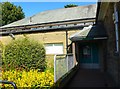
Entrance to Buxton Library, Kents Bank Road
Image: © Peter Barr
Taken: 21 Jan 2010
0.02 miles
3
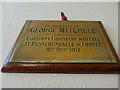
Inside Buxton Library (ii)
Also see http://www.cwgc.org/find-war-dead/casualty/563224/MITCHELL,%20G
Image: © Basher Eyre
Taken: 30 Jul 2015
0.07 miles
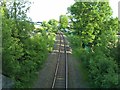
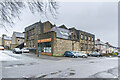
6
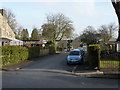
Kent's Bank Road
Looking along Kent's Bank Road, a road first shown on the 1898 25" map but without development, the houses first being shown on the 1922 edition. On the right is Cote Heath Park.
Image: © Ian Capper
Taken: 12 Mar 2024
0.09 miles
7
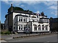
The Robin Hood
On the A515 to the south of Buxton
Image: © Graham Hogg
Taken: 8 Aug 2012
0.10 miles
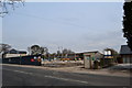
8
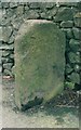
Old Milestone by the A515, London Road, Buxton
Carved stone post by the A515, in parish of BUXTON (HIGH PEAK District), London Road, in tarmac pavement in front of stone wall, on West side of road, South of Heath Grove junction. Buxton marker, erected by the Macclesfield & Buxton turnpike trust in the 19th century.
Inscription once read:-
: (Stockport 19) : : (Ashbourne 20) :
Carved bench mark on top.
Milestone Society National ID: DE_BXAB00.
Image: © J Higgins
Taken: 10 Dec 2017
0.11 miles
9
Byron Street Works
Former bakery on the corner of Byron Street and Heath Park Road. Originally built in the 1920s and later extended, in the 1970s it became home to a supplier of grinding and polishing products to the aerospace and automotive industries. The offices are now used by a computer firm and as a business centre for small businesses.
Image: © Ian Capper
Taken: 12 Mar 2024
0.13 miles
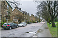
10
Care Home being built on London Road
This site used to have a block of flats, named Haddon Hall. It stood derelict for many years, then burned down one night.Now the developers and builders are in.
Image: © Peter Barr
Taken: 8 Apr 2013
0.14 miles