IMAGES TAKEN NEAR TO
Temple Road, BUXTON, SK17 9BZ
Introduction
This page details the photographs taken nearby to Temple Road, SK17 9BZ by members of the Geograph project.
The Geograph project started in 2005 with the aim of publishing, organising and preserving representative images for every square kilometre of Great Britain, Ireland and the Isle of Man.

There are currently over 7.5m images from over14,400 individuals and you can help contribute to the project by visiting https://www.geograph.org.uk
Image Map
Images are licensed for reuse under creativecommons.org/licenses/by-sa/2.0
Notes
- Clicking on the map will re-center to the selected point.
- The higher the marker number, the further away the image location is from the centre of the postcode.
Image Listing (121 Images Found)
Images are licensed for reuse under creativecommons.org/licenses/by-sa/2.0
Image
Details
Distance
1
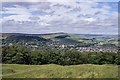
Buxton : view from Grinlow Tower (Solomon's Temple)
Image: © Jim Osley
Taken: 22 Jul 2019
0.02 miles
2
Buxton : view from Grinlow Tower (Solomon's Temple)
Image: © Jim Osley
Taken: 22 Jul 2019
0.02 miles
3
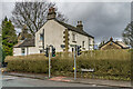
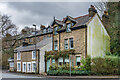
Bath House
18th Century house at 2 Macclesfield Road. Grade II listed - see https://historicengland.org.uk/listing/the-list/list-entry/1259181?section=official-list-entry. The 1879 1:500 plan shows a disused "tonic bath" behind the house (later maps up to and including the 1922 25" map show it as a swimming bath), which may explain its name.
Image: © Ian Capper
Taken: 12 Mar 2024
0.03 miles
4
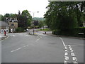
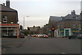
Buxton - Burlington Road
Looking in the direction of Macclesfield Road.
Image: © Alan Heardman
Taken: 22 Jun 2009
0.03 miles
6
75 - 79 West Road
Pair of houses on West Road, shown on the 1879 1:500 plan. Beyond is Belvedere Terrace, dated 1877, also shown on the same map.
Image: © Ian Capper
Taken: 12 Mar 2024
0.04 miles
7
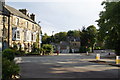
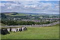
Multiple junction at the bottom of Burlington Road
Six roads converge here, in this area of older graceful housing.
Image: © Bill Boaden
Taken: 8 Sep 2012
0.05 miles
8
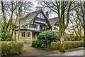
Seven Ways and Somersby
Semi-detached pair of late 19th Century houses at 1 & 3 College Road, built in 1895 designed in "Cheshire revival" style by Barry Parker. Grade II listed - see https://historicengland.org.uk/listing/the-list/list-entry/1259367?section=official-list-entry.
Image: © Ian Capper
Taken: 12 Mar 2024
0.05 miles
9
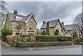
10 Macclesfield Road
Large Edwardian house on Macclesfield Road first shown on the 1922 25" map. Those beyond, nos 8 and 6 are slightly earlier, being shown on the 1898 edition.
Image: © Ian Capper
Taken: 12 Mar 2024
0.05 miles
10
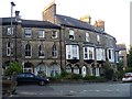
1 - 6 Bath Road
Six town houses. Built in the early 19th century with late 19th century additions and 20th century alterations. These delightful houses are listed, grade II, with details at: https://www.historicengland.org.uk/listing/the-list/list-entry/1259440
Image: © Michael Dibb
Taken: 1 Jul 2018
0.06 miles