IMAGES TAKEN NEAR TO
Old Dam, BUXTON, SK17 8EN
Introduction
This page details the photographs taken nearby to Old Dam, SK17 8EN by members of the Geograph project.
The Geograph project started in 2005 with the aim of publishing, organising and preserving representative images for every square kilometre of Great Britain, Ireland and the Isle of Man.

There are currently over 7.5m images from over14,400 individuals and you can help contribute to the project by visiting https://www.geograph.org.uk
Image Map
Images are licensed for reuse under creativecommons.org/licenses/by-sa/2.0
Notes
- Clicking on the map will re-center to the selected point.
- The higher the marker number, the further away the image location is from the centre of the postcode.
Image Listing (27 Images Found)
Images are licensed for reuse under creativecommons.org/licenses/by-sa/2.0
Image
Details
Distance
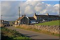
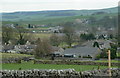
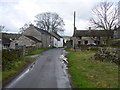
2
Old Dam near Peak Forest
Houses by the lane junction.
Image: © Andrew Hill
Taken: 21 Mar 2012
0.02 miles
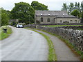
3
Above Peak Forest village
View from the lower section of Eldon Lane by a footpath crossing.
Image: © Andrew Hill
Taken: 21 Mar 2012
0.03 miles
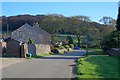
4
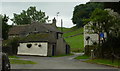
Old Dam lane
Cottages by the start of the lane.
Image: © Andrew Hill
Taken: 17 Aug 2012
0.04 miles
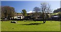
5
Old Dam Lane
Sweetknowle Farm left of the lane, the entrance to Greenhead Farm on the right.
Image: © Dave Dunford
Taken: 3 Jun 2006
0.04 miles
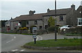
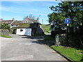
8
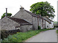
Old Dam
Buildings on Old Dam Lane. Old Dam is a Hamlet near to Peak Forest.
Image: © Stephen Burton
Taken: 17 May 2018
0.06 miles