IMAGES TAKEN NEAR TO
Cowlow Lane, BUXTON, SK17 8DF
Introduction
This page details the photographs taken nearby to Cowlow Lane, SK17 8DF by members of the Geograph project.
The Geograph project started in 2005 with the aim of publishing, organising and preserving representative images for every square kilometre of Great Britain, Ireland and the Isle of Man.

There are currently over 7.5m images from over14,400 individuals and you can help contribute to the project by visiting https://www.geograph.org.uk
Image Map
Images are licensed for reuse under creativecommons.org/licenses/by-sa/2.0
Notes
- Clicking on the map will re-center to the selected point.
- The higher the marker number, the further away the image location is from the centre of the postcode.
Image Listing (8 Images Found)
Images are licensed for reuse under creativecommons.org/licenses/by-sa/2.0
Image
Details
Distance
3
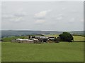
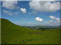
Cowlow
Cowlow farm nestles in a fold in the hills above Chapel en le Frith. This is the view looking east from the entrance to the farm on Ridge Lane.
Image: © Roger May
Taken: 11 Dec 2005
0.05 miles
4

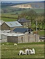
Cowlow, a hill farm in the Peak District
Dairy farm near Dove Holes, north of Buxton.
Image: © Peter Barr
Taken: 31 Aug 2010
0.05 miles
6
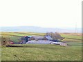
A glimpse of Chapel- en- le- Frith
View north from Cowlow, towards the town in the valley.
Image: © Peter Barr
Taken: 31 Aug 2010
0.15 miles
7
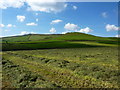
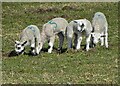
Short Edge,northern edge of Coombs Moss
From a path leaving Dove Holes, to Cowlow.The grass has been cut, turned and later today will be baled for winter fodder.
Image: © Peter Barr
Taken: 31 Aug 2010
0.17 miles
8
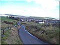
Cowlow Lane, Dove Holes
Heading into Dove Holes on a mild Saturday in mid February.
Image: © Jonathan Clitheroe
Taken: 12 Feb 2011
0.20 miles