IMAGES TAKEN NEAR TO
Cromford Place, BUXTON, SK17 7RN
Introduction
This page details the photographs taken nearby to Cromford Place, SK17 7RN by members of the Geograph project.
The Geograph project started in 2005 with the aim of publishing, organising and preserving representative images for every square kilometre of Great Britain, Ireland and the Isle of Man.

There are currently over 7.5m images from over14,400 individuals and you can help contribute to the project by visiting https://www.geograph.org.uk
Image Map
Images are licensed for reuse under creativecommons.org/licenses/by-sa/2.0
Notes
- Clicking on the map will re-center to the selected point.
- The higher the marker number, the further away the image location is from the centre of the postcode.
Image Listing (6 Images Found)
Images are licensed for reuse under creativecommons.org/licenses/by-sa/2.0
Image
Details
Distance
1
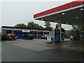
Petrol station in Buxton
Filling station and shop on London Road, Buxton.
Image: © Eirian Evans
Taken: 27 Oct 2007
0.21 miles
2
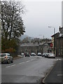
London Road, Buxton
The A6 going into Buxton.
Image: © Eirian Evans
Taken: 27 Oct 2007
0.21 miles
4
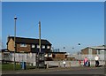
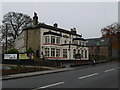
Walking by "The Royal Forester"
On the Fairfield Estate, Buxton. Sadly, this is yet another pub that seems to have closed its doors forever.
Image: © Neil Theasby
Taken: 12 Mar 2014
0.23 miles
5
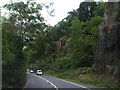
The Robin Hood
A public house on the A6 in Buxton.
Image: © Eirian Evans
Taken: 27 Oct 2007
0.23 miles
6
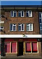
China House with flats above, Buxton
On Victoria Park Road - Fairfield Estate, Buxton
Image: © Neil Theasby
Taken: 12 Mar 2014
0.25 miles