IMAGES TAKEN NEAR TO
Waterswallows Lane, BUXTON, SK17 7JD
Introduction
This page details the photographs taken nearby to Waterswallows Lane, SK17 7JD by members of the Geograph project.
The Geograph project started in 2005 with the aim of publishing, organising and preserving representative images for every square kilometre of Great Britain, Ireland and the Isle of Man.

There are currently over 7.5m images from over14,400 individuals and you can help contribute to the project by visiting https://www.geograph.org.uk
Image Map
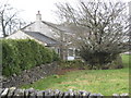
Images are licensed for reuse under creativecommons.org/licenses/by-sa/2.0
Notes
- Clicking on the map will re-center to the selected point.
- The higher the marker number, the further away the image location is from the centre of the postcode.
Image Listing (15 Images Found)
Images are licensed for reuse under creativecommons.org/licenses/by-sa/2.0
Image
Details
Distance
2
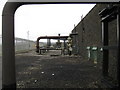
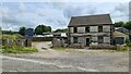
Gas pipeline pumping station-South side
Image: © Dr Duncan Pepper
Taken: 30 Mar 2010
0.05 miles
3
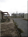
Gas pipeline pumping station-North side
Image: © Dr Duncan Pepper
Taken: 30 Mar 2010
0.06 miles
6
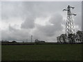
Pylons heading South towards Buxton
Image: © Dr Duncan Pepper
Taken: 30 Mar 2010
0.10 miles
7
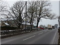
Thundering towards the A6
Lorries leave industrial units at Waterswallows, passing Breezemount Farm, while postie waits for a gap in the traffic
Image: © Peter Barr
Taken: 19 Feb 2010
0.14 miles
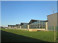
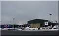
8

"Nestle Waters" industrial premises
At Waterswallows, this £35 million bottling plant opened on March 14th 2013.
Image: © Neil Theasby
Taken: 12 Mar 2014
0.14 miles
9
Recycling depot at Waterswallow, near Buxton
Image: © Peter Barr
Taken: 19 Feb 2010
0.15 miles
10
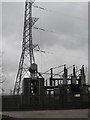
Electricity substation-South side
Image: © Dr Duncan Pepper
Taken: 30 Mar 2010
0.18 miles