IMAGES TAKEN NEAR TO
Brown Edge Road, BUXTON, SK17 7AL
Introduction
This page details the photographs taken nearby to Brown Edge Road, SK17 7AL by members of the Geograph project.
The Geograph project started in 2005 with the aim of publishing, organising and preserving representative images for every square kilometre of Great Britain, Ireland and the Isle of Man.

There are currently over 7.5m images from over14,400 individuals and you can help contribute to the project by visiting https://www.geograph.org.uk
Image Map
Images are licensed for reuse under creativecommons.org/licenses/by-sa/2.0
Notes
- Clicking on the map will re-center to the selected point.
- The higher the marker number, the further away the image location is from the centre of the postcode.
Image Listing (35 Images Found)
Images are licensed for reuse under creativecommons.org/licenses/by-sa/2.0
Image
Details
Distance
1
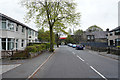
Lightwood Road
These houses are rather more modern than many in the middle of Buxton.
Image: © Malcolm Neal
Taken: 7 May 2019
0.11 miles
2
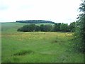
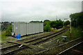
Meadow viewed from Brown Edge Road
The Brownedge Plantation and TV mast (SK0575) can also be seen on the horizon.
Image: © Jonathan Clitheroe
Taken: 25 Jun 2012
0.12 miles
3
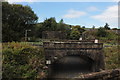
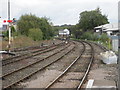
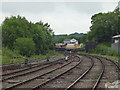
Buxton railway junction
Taken from a train approaching from the old Midland Line through Peak Forest, now freight only. The nearer bridge is the old LNWR line that is still open for passenger traffic. The station is to the left of this picture.
Image: © Robert Eva
Taken: 17 Sep 2016
0.13 miles
4

NEW
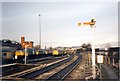
Buxton signalbox
The box controls the junction between the passenger lines out of the station, and the two single track freight branches that still serve nearby stone quarries. Buxton once had a surprisingly dense railway network for a town of its size, with two passenger stations and several freight lines. The box dates from 1894, refurbished 2004. A detailed description and interior photos can be found on another site https://www.flickr.com/photos/ingythewingy/5915146188/
Image: © Stephen Craven
Taken: 2 Mar 2025
0.14 miles
5
Buxton locomotive depot
The depot provided for many years outside Buxton station for diesel locomotives hauling stone out of the local area. Now closed with replacement facilities at Great Rocks junction. The earlier steam locomotive depot was behind Buxton signalbox, visible in the centre distance.
Image: © Peter Whatley
Taken: 26 Jan 1991
0.15 miles
6
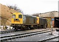
Class 20 Locomotives at Buxton, 1986
A pair of Class 20 diesel electric locomotives, Nos 20168 and 20134, outside the depot building at Buxton in the winter of 1986
Image: © Rob Newman
Taken: 11 Jan 1986
0.15 miles
7
The former Ashbourne and Buxton Railway, Derbyshire
This single track now terminates at the limestone works at Dow Low.
Image: © Roger D Kidd
Taken: 6 Sep 2014
0.16 miles
8
Buxton railway station, Derbyshire
Opened in 1863 by the London & North Western Railway, on what is today the line from Manchester to Buxton.
View north east towards the signalbox, Dove Holes and Manchester.
Image: © Nigel Thompson
Taken: 6 Oct 2012
0.16 miles
9
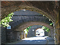
Buxton - railway bridges over Lightwood Road
The nearest bridge carries the ex-LNW lines from Hazel Grove into Buxton Station. The middle bridge carries the ex-MR freight-only line to Chinley via Peak Forest. The far bridge carries the ex-LNW freight-only line to Dowlow and Hindlow.
Image: © Dave Bevis
Taken: 6 Jul 2013
0.17 miles
10
Buxton: signal box
Looking northwest from the end of the platform at Buxton, the still-used signal box is seen, partially obscured by a train of stone hoppers coming off the Midland line.
Image: © Dr Neil Clifton
Taken: 28 Jun 2012
0.17 miles