IMAGES TAKEN NEAR TO
Brown Edge Road, BUXTON, SK17 7AG
Introduction
This page details the photographs taken nearby to Brown Edge Road, SK17 7AG by members of the Geograph project.
The Geograph project started in 2005 with the aim of publishing, organising and preserving representative images for every square kilometre of Great Britain, Ireland and the Isle of Man.

There are currently over 7.5m images from over14,400 individuals and you can help contribute to the project by visiting https://www.geograph.org.uk
Image Map
Images are licensed for reuse under creativecommons.org/licenses/by-sa/2.0
Notes
- Clicking on the map will re-center to the selected point.
- The higher the marker number, the further away the image location is from the centre of the postcode.
Image Listing (10 Images Found)
Images are licensed for reuse under creativecommons.org/licenses/by-sa/2.0
Image
Details
Distance
1
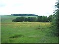
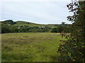
Meadow viewed from Brown Edge Road
The Brownedge Plantation and TV mast (SK0575) can also be seen on the horizon.
Image: © Jonathan Clitheroe
Taken: 25 Jun 2012
0.08 miles
2
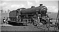
LNER B1 4-6-0 on turntable at Buxton during 1963 Rail Tour
View eastward, on northern edge of Buxton. The former London & North Western engine shed was to the left, beside the line to Manchester via Chapel-en-le-Frith. The Rail Tour, organised by the Railway Correspondence & Travel Society, was fascinating:- London St Pancras - Derby - Chaddesden Loop - Trent - Codnor Park - Butterley - Ambergate - Matlock - Buxton - Ashbourne - Uttoxeter - Tutbury - Burton-on-Trent - Ashby-de-la-Zouch - Coalville - Knighton South Junction, then back to St Pancras on the main line. But it was rather stressful and a great rush, as SR 'West Country' 34006 steamed badly, getting to Derby 80 minutes late and we had to skip a Works Visit. B1 61004 took over at Derby and hauled us all the complex way via Buston and back to Burton, where 34006 - which now felt a little better - took over again but had a struggle to get back to St Pancras, reached at 22.15 ('only' 40 minutes late).
Image: © Ben Brooksbank
Taken: 11 May 1963
0.09 miles
3
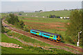
Passenger Train near Buxton
Passenger train approaches its destination of Buxton.
Image: © Wayland Smith
Taken: 24 May 2008
0.14 miles
4
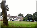
Reaching Fairfield Common
As one leaves Buxton on the A6, heading for Stockport, at the top of the hill the town ends at the golf course and Fairfield Common. These buildings stand in a row in front of the church.
Image: © Roger May
Taken: 29 Aug 2005
0.21 miles
5

NEW
Buxton signalbox
The box controls the junction between the passenger lines out of the station, and the two single track freight branches that still serve nearby stone quarries. Buxton once had a surprisingly dense railway network for a town of its size, with two passenger stations and several freight lines. The box dates from 1894, refurbished 2004. A detailed description and interior photos can be found on another site https://www.flickr.com/photos/ingythewingy/5915146188/
Image: © Stephen Craven
Taken: 2 Mar 2025
0.23 miles
6
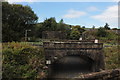
Buxton railway junction
Taken from a train approaching from the old Midland Line through Peak Forest, now freight only. The nearer bridge is the old LNWR line that is still open for passenger traffic. The station is to the left of this picture.
Image: © Robert Eva
Taken: 17 Sep 2016
0.23 miles
8
Houses and fields in the north of Buxton
Taken from Brown Edge Road.
Image: © Peter Barr
Taken: 4 Sep 2010
0.23 miles
9
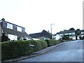
Lightwood Road
These houses are rather more modern than many in the middle of Buxton.
Image: © Malcolm Neal
Taken: 7 May 2019
0.24 miles
10
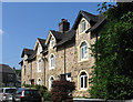
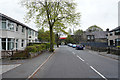
Buxton - Hogshaw Villas Road
House numbers 19 to 25.
Image: © Dave Bevis
Taken: 6 Jul 2013
0.24 miles