IMAGES TAKEN NEAR TO
Peveril Road, BUXTON, SK17 6PA
Introduction
This page details the photographs taken nearby to Peveril Road, SK17 6PA by members of the Geograph project.
The Geograph project started in 2005 with the aim of publishing, organising and preserving representative images for every square kilometre of Great Britain, Ireland and the Isle of Man.

There are currently over 7.5m images from over14,400 individuals and you can help contribute to the project by visiting https://www.geograph.org.uk
Image Map
Images are licensed for reuse under creativecommons.org/licenses/by-sa/2.0
Notes
- Clicking on the map will re-center to the selected point.
- The higher the marker number, the further away the image location is from the centre of the postcode.
Image Listing (72 Images Found)
Images are licensed for reuse under creativecommons.org/licenses/by-sa/2.0
Image
Details
Distance
1
![Over Dale Road [1]](https://s3.geograph.org.uk/geophotos/05/87/56/5875623_12f8e9a6_120x120.jpg)
Over Dale Road [1]
The bridge carries the railway over Dale Road.
Image: © Michael Dibb
Taken: 1 Jul 2018
0.03 miles
2
![Over Dale Road [2]](https://s1.geograph.org.uk/geophotos/05/87/56/5875625_d775e885_120x120.jpg)
Over Dale Road [2]
The bridge carries the railway over Dale Road. The join where the bridge was widened from one track to two is clearly seen.
Image: © Michael Dibb
Taken: 1 Jul 2018
0.03 miles

4

Buxton: near site of former Higher Buxton station, 1995
View eastward on Dale Road. The bridge carried the ex-LNW line to Ashbourne, which was closed mainly on 1/11/54, the station having been on the left and was closed since 2/4/51, but limestone trains ran still ran over it from Hindlow at least until 1964.
Image: © Ben Brooksbank
Taken: 28 May 1995
0.03 miles


7

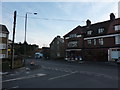
36 - 42 Dale Road
Small parade of shops on Dale Road by its junction with Heath Park Road, first shown on the 1946 6" map.
Image: © Ian Capper
Taken: 12 Mar 2024
0.09 miles
9
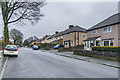
Heath Park Road
Houses in Heath Park Road, first shown on the 1946 6" map.
Image: © Ian Capper
Taken: 12 Mar 2024
0.11 miles
