IMAGES TAKEN NEAR TO
Dale Road, BUXTON, SK17 6NL

Introduction

This page details the photographs taken nearby to Dale Road, SK17 6NL by members of the Geograph project.

The Geograph project started in 2005 with the aim of publishing, organising and preserving representative images for every square kilometre of Great Britain, Ireland and the Isle of Man.

There are currently over 7.5m images from over14,400 individuals and you can help contribute to the project by visiting https://www.geograph.org.uk

Image Map


Images are licensed for reuse under creativecommons.org/licenses/by-sa/2.0
Notes
  • Clicking on the map will re-center to the selected point.
  • The higher the marker number, the further away the image location is from the centre of the postcode.

Image Listing (209 Images Found)

Images are licensed for reuse under creativecommons.org/licenses/by-sa/2.0
  • ...
Image
Details
Distance
1
Fake half-timbering in Dale Road, Buxton
Image: © David Smith Taken: 1 Sep 2017
0.01 miles
2
37 - 53 Dale Road
Terraces of houses in Dale Road first shown on the 1898 25" map.
Image: © Ian Capper Taken: 12 Mar 2024
0.02 miles
3
Houses on Dale Road - Buxton
Image: © Anthony Parkes Taken: 12 May 2012
0.02 miles
4
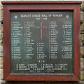
Bennett Street War Memorial
War memorial on the wall of 28 Dale Road, at the corner of that road and Bennett Street (see Image) commemorating the 104 residents of Bennett Street who served in the First World War (including 11 deaths) and 1 death in the Second World War. The current memorial dates from 1966 (later restored in 2017), replacing an earlier memorial of 1917 and added to later, the cross from which is now in the St Mary's Church, along Dale Road.
Image: © Ian Capper Taken: 12 Mar 2024
0.02 miles
5
Bennett Street
Looking along Bennett Street, a road of 19th Century terraced housing first shown on the 1898 25" map.
Image: © Ian Capper Taken: 12 Mar 2024
0.03 miles
6
Bennett Street
Looking along Bennett Street, a road of 19th Century terraced housing first shown on the 1898 25" map. The house on the corner, 28 Dale Road, is slightly later, not being shown until the 1922 25" map. On its wall is the Bennett Street War Memorial - see Image
Image: © Ian Capper Taken: 12 Mar 2024
0.03 miles
7
Buxton Tandoori; late July 2015
Image: © Basher Eyre Taken: 30 Jul 2015
0.03 miles
8
Unusual gable end
This unusual property is on the corner of Dale Road and Bennett Street.
Image: © Michael Dibb Taken: 1 Jul 2018
0.04 miles
9
Victorian postbox, Buxton
Victorian postbox SK17 32 is at the corner of Market Street (left) and Dale Road.
Image: © Derek Harper Taken: 8 Jul 2014
0.04 miles
10
New Market Street, Buxton
Leading to Market Street and the town centre.
Image: © Derek Harper Taken: 8 Jul 2014
0.04 miles
  • ...