IMAGES TAKEN NEAR TO
Church Street, BUXTON, SK17 6HD
Introduction
This page details the photographs taken nearby to Church Street, SK17 6HD by members of the Geograph project.
The Geograph project started in 2005 with the aim of publishing, organising and preserving representative images for every square kilometre of Great Britain, Ireland and the Isle of Man.

There are currently over 7.5m images from over14,400 individuals and you can help contribute to the project by visiting https://www.geograph.org.uk
Image Map
Images are licensed for reuse under creativecommons.org/licenses/by-sa/2.0
Notes
- Clicking on the map will re-center to the selected point.
- The higher the marker number, the further away the image location is from the centre of the postcode.
Image Listing (234 Images Found)
Images are licensed for reuse under creativecommons.org/licenses/by-sa/2.0
Image
Details
Distance
1
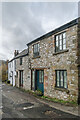
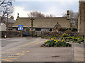
14 - 16 Church Street
17th Century cottage on Church Street with a name plaque "The Smithy", now in residential use but shown on the 1879 1:500 plan as a Smithy.
Image: © Ian Capper
Taken: 12 Mar 2024
0.00 miles
2
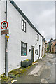
18 Church Street
17th Century cottage on Church Street with a name plaque "Smithy's Cottage", shown on the 1879 1:500 plan. This map shows the building beyond (now houses, nos 14 & 16) as a Smithy, with no 18 presumably being the smith's home.
Image: © Ian Capper
Taken: 12 Mar 2024
0.01 miles
3
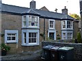
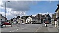
The Old Wheatsheaf
A former public house in the narrow streets around the church of St Anne.
Image: © Michael Dibb
Taken: 1 Jul 2018
0.01 miles
4
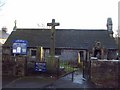
Church of St Anne on Bath Road, Buxton
Ornate and ancient place of worship and the oldest building in the town. The church is situated in SK0572 but the photographer position is just outside the gridsquare in SK0573, hence a supplemental image.
Image: © Jonathan Clitheroe
Taken: 12 Feb 2011
0.01 miles
6
Fiveways Crossing on A515, London Road, Buxton
Image: © Chris Morgan
Taken: 8 Aug 2012
0.02 miles
7
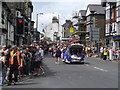
Carnival Procession at Buxton
Dozens of highly decorated cars and floats proceed towards the town centre, many with carnival queens and attendants
Image: © Eirian Evans
Taken: 13 Jul 2014
0.03 miles
8
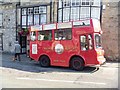
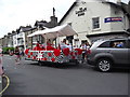
Converted milk float
The float has been converted into a small Victorian tram and is used to give tours of Buxton.
Image: © Michael Dibb
Taken: 25 Jun 2018
0.03 miles
9
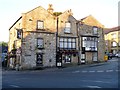
The Swan
In an important position in the High Street, The Swan has been previously known as The Shoulder of Mutton and The White Swan. The building is listed, grade II, with details at: https://www.historicengland.org.uk/listing/the-list/list-entry/1259407
Image: © Michael Dibb
Taken: 1 Jul 2018
0.03 miles
10
Carnival Float passing the London Road Inn
The July Buxton Carnival procession comes down West Road and turns up the High Street
Image: © Eirian Evans
Taken: 13 Jul 2014
0.03 miles