IMAGES TAKEN NEAR TO
Quarnford, BUXTON, SK17 0TQ
Introduction
This page details the photographs taken nearby to SK17 0TQ by members of the Geograph project.
The Geograph project started in 2005 with the aim of publishing, organising and preserving representative images for every square kilometre of Great Britain, Ireland and the Isle of Man.

There are currently over 7.5m images from over14,400 individuals and you can help contribute to the project by visiting https://www.geograph.org.uk
Image Map
Images are licensed for reuse under creativecommons.org/licenses/by-sa/2.0
Notes
- Clicking on the map will re-center to the selected point.
- The higher the marker number, the further away the image location is from the centre of the postcode.
Image Listing (4 Images Found)
Images are licensed for reuse under creativecommons.org/licenses/by-sa/2.0
Image
Details
Distance
1
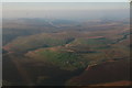
View towards Knotbury Farm
This picture was taken about a mile to the north west of Flash village. On stopping to capture this rural scene I dropped my map - an oversight which will no doubt be of little interest to anyone else, but a slip that added a good mile onto the day's ramble. The narrow lane winding its way up to Wolf Edge (far right of shot) is where the missing accessory was eventually clocked.
Image: © Jonathan Clitheroe
Taken: 8 Aug 2009
0.05 miles