IMAGES TAKEN NEAR TO
Quarnford, BUXTON, SK17 0ST
Introduction
This page details the photographs taken nearby to SK17 0ST by members of the Geograph project.
The Geograph project started in 2005 with the aim of publishing, organising and preserving representative images for every square kilometre of Great Britain, Ireland and the Isle of Man.

There are currently over 7.5m images from over14,400 individuals and you can help contribute to the project by visiting https://www.geograph.org.uk
Image Map
Images are licensed for reuse under creativecommons.org/licenses/by-sa/2.0
Notes
- Clicking on the map will re-center to the selected point.
- The higher the marker number, the further away the image location is from the centre of the postcode.
Image Listing (15 Images Found)
Images are licensed for reuse under creativecommons.org/licenses/by-sa/2.0
Image
Details
Distance
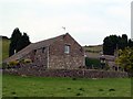
1
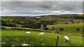
Far Brook
Looking down into Far Brook.
Image: © Peter McDermott
Taken: 13 Aug 2016
0.02 miles
2
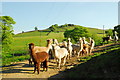
Alpacas in Staffordshire
A small flock (herd? pack? don't know what the collective noun is for them) of alpacas at Far Brook Farm in the Peak District. It's quite common to find these South American relatives of the llama being farmed in the UK for their wool, which is very fine and a superb insulator. I got this information from a sign at the farm, whose owners are obviously alpaca enthusiasts.
Image: © John Winder
Taken: 18 May 2014
0.03 miles
3
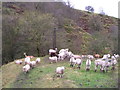
Long and short necks
Alpacas and sheep.
Image: © Marion Phillips
Taken: 1 Nov 2012
0.05 miles
4
Farbrook Farm
Looking west, Alpacas in foreground. Bosley Cloud visible in distance
Image: © Philip Cornwall
Taken: 6 Jun 2020
0.07 miles
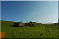
5
Pasture at Axe Edge Green Farm
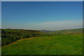
I originally titled this "Meadow at Axe Edge Green Farm", but my girlfriend, who is a proper ecologist with certificates and everything, told me that it isn't really a meadow since there's actually very little ecological diversity in it. The very vivid green (not a camera trick, by the way; it really was this colour!) indicates that the ground has been "improved" by fertiliser, which allows a few species of plant to flourish at the expense of a wider variety of more interesting plants. Anyway, I thought it was worth a photograph for the colours alone.
Image: © John Winder
Taken: 18 May 2014
0.09 miles
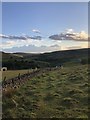
6
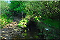
Stream near Flash
This unnamed beck flows from Axe Edge to the River Dane. It's forded here by a bridleway and bridged by a footpath to Flash.
Image: © John Winder
Taken: 18 May 2014
0.13 miles
7
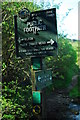
Footpath sign in North Staffordshire
This caught my eye on a circular walk around Flash. Self explanatory really. I followed the path back to Flash, where I was staying for the weekend.
Image: © John Winder
Taken: 18 May 2014
0.13 miles
10
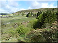
Axe Edge Green Farm in spring
Taken from the public footpath which runs from Three Shires Head to Flash (see Image). The colours here are not exaggerated by camera settings, it really did look like this in the early morning spring sunshine!
Image: © John Winder
Taken: 18 May 2014
0.17 miles