IMAGES TAKEN NEAR TO
Brandside, BUXTON, SK17 0SE
Introduction
This page details the photographs taken nearby to SK17 0SE by members of the Geograph project.
The Geograph project started in 2005 with the aim of publishing, organising and preserving representative images for every square kilometre of Great Britain, Ireland and the Isle of Man.

There are currently over 7.5m images from over14,400 individuals and you can help contribute to the project by visiting https://www.geograph.org.uk
Image Map
Images are licensed for reuse under creativecommons.org/licenses/by-sa/2.0
Notes
- Clicking on the map will re-center to the selected point.
- The higher the marker number, the further away the image location is from the centre of the postcode.
Image Listing (17 Images Found)
Images are licensed for reuse under creativecommons.org/licenses/by-sa/2.0
Image
Details
Distance

2
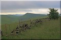
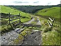
Ruined Dry Stone Wall
Brand End (Image) in the distance.
Image: © Mick Garratt
Taken: 1 Jul 2012
0.08 miles
4
Fairthorn
Looking east on a murky day with Thirkelow Rocks on the horizon.
Image: © Dave Dunford
Taken: 30 Apr 2006
0.12 miles
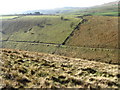
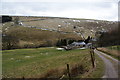
5
Fairthorn and Greenland
From the entrance track to Fairthorn, which is the farm in the valley; Greenland is on the ridge behind, and in the background is Axe Edge.
Image: © Dave Dunford
Taken: 30 Apr 2006
0.12 miles

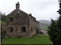
8
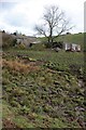
Roundknow Farm
The little used Public Footpath crosses the quagmire in front of the farm.
Image: © Mick Garratt
Taken: 28 Apr 2012
0.14 miles
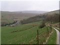
9
Fairthorn
A quiet location at the bottom of Cistern's Clough.
Image: © Bill Boaden
Taken: 23 Feb 2013
0.16 miles
10
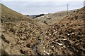
Cistern's Clough
Still a narrow stream with a reasonably sized clough, as it makes its way towards the River Dove.
Image: © Bill Boaden
Taken: 23 Feb 2013
0.18 miles