IMAGES TAKEN NEAR TO
Longnor, BUXTON, SK17 0PU
Introduction
This page details the photographs taken nearby to SK17 0PU by members of the Geograph project.
The Geograph project started in 2005 with the aim of publishing, organising and preserving representative images for every square kilometre of Great Britain, Ireland and the Isle of Man.

There are currently over 7.5m images from over14,400 individuals and you can help contribute to the project by visiting https://www.geograph.org.uk
Image Map
Images are licensed for reuse under creativecommons.org/licenses/by-sa/2.0
Notes
- Clicking on the map will re-center to the selected point.
- The higher the marker number, the further away the image location is from the centre of the postcode.
Image Listing (13 Images Found)
Images are licensed for reuse under creativecommons.org/licenses/by-sa/2.0
Image
Details
Distance
1
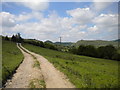
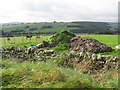
Farm track north of Longnor
This track runs along the south western (Staffordshire) side of the valley of the River Dove. The hills on the right and in the centre of this picture are in Derbyshire.
Image: © Richard Vince
Taken: 8 Jun 2013
0.05 miles
2
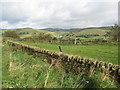
Buxton Road (B5053) View
Dry stone walls and rolling hills, that's Derbyshire.
Image: © Alan Heardman
Taken: 30 Sep 2009
0.07 miles
5
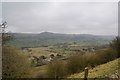
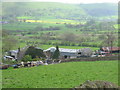
The valley of the Dove
Yewtree Grange is at the bottom, and High Wheeldon on the other side. This was taken from the Buxton road.
Image: © Bill Boaden
Taken: 28 Feb 2009
0.12 miles
6
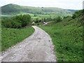
Buxton Road (B5053) View just outside Longnor
If donkeys could talk, they would probably be saying, "we didn't do all that".
Image: © Alan Heardman
Taken: 30 Sep 2009
0.13 miles
7
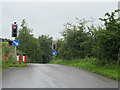
Rural traffic lights
At the junction of the B5053 with the minor road to Hollinsclough.
Image: © John H Darch
Taken: 15 Jul 2020
0.14 miles
8
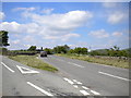
B5053 north of Longnor
Just north of its junction with a narrow lane to Hollinsclough (left), the B5053 is subject to unidirectional traffic control, hence the traffic lights. The car is awaiting a green light to continue down the hill towards Buxton.
Image: © Richard Vince
Taken: 8 Jun 2013
0.15 miles
9
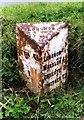
Old Milepost by the B5053, Longnor parish
Cast iron post by the B5053, in parish of Longnor (Staffordshire Moorlands District), above "Under the Hill", on the verge, on West side of B5053 on grass island. Lathe iron casting, erected by the County Council in the 19th/20th century.
Inscription reads:-
: BUXTON 5½ (listing shows 6½) : : LONGNOR : : LONGNOR ½ / WARSLOW 4¾ / ONECOTE 8 / IPSTONES 12 / FROGHALL 14 / CHEADLE 17 :
Maker:-
: Chas. Lathe, Tipton. :
Grade II listed.
List Entry Number: 1262232 https://historicengland.org.uk/listing/the-list/list-entry/1262232
Milestone Society National ID: ST_CDBX17
Image: © J Higgins
Taken: 1 Jan 2000
0.15 miles
10
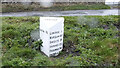
Old Milepost by the B5053, Longnor parish
Cast iron post by the B5053, in parish of Longnor (Staffordshire Moorlands District), above "Under the Hill", on the verge, on West side of B5053 on grass island. Lathe iron casting, erected by the County Council in the 19th/20th century.
Inscription reads:-
: BUXTON 5½ (listing shows 6½) : : LONGNOR : : LONGNOR ½ / WARSLOW 4¾ / ONECOTE 8 / IPSTONES 12 / FROGHALL 14 / CHEADLE 17 :
Maker:-
: Chas. Lathe, Tipton. :
Grade II listed.
List Entry Number: 1262232 https://historicengland.org.uk/listing/the-list/list-entry/1262232
Milestone Society National ID: ST_CDBX17
Image: © Dave Smith
Taken: 24 May 2024
0.15 miles