IMAGES TAKEN NEAR TO
Longnor, BUXTON, SK17 0PH
Introduction
This page details the photographs taken nearby to SK17 0PH by members of the Geograph project.
The Geograph project started in 2005 with the aim of publishing, organising and preserving representative images for every square kilometre of Great Britain, Ireland and the Isle of Man.

There are currently over 7.5m images from over14,400 individuals and you can help contribute to the project by visiting https://www.geograph.org.uk
Image Map
Images are licensed for reuse under creativecommons.org/licenses/by-sa/2.0
Notes
- Clicking on the map will re-center to the selected point.
- The higher the marker number, the further away the image location is from the centre of the postcode.
Image Listing (167 Images Found)
Images are licensed for reuse under creativecommons.org/licenses/by-sa/2.0
Image
Details
Distance
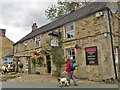
1
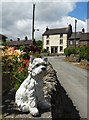
Approaching High Street, Longnor
A concrete "westie" guards the way but doesn't bark.
Image: © Neil Theasby
Taken: 6 Jun 2015
0.02 miles
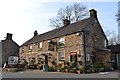
2
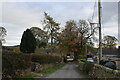
Access Lane leading to Folds End Farm
Adopted by the Manifold Trail long distance footpath, this access lane heads off the High Street in Longnor towards Folds End Farm
Image: © Chris Heaton
Taken: 3 Nov 2021
0.03 miles
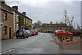
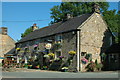
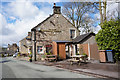
5
Ye Olde Cheshire Cheese
Old pub in Longnor.
Image: © steven ruffles
Taken: 30 Aug 2020
0.03 miles
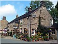
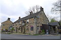
8
Ye Olde Cheshire Cheese Inn, Longnor
http://www.geograph.org.uk/photo/4889109 http://www.geograph.org.uk/photo/4889110
Image: © Ian S
Taken: 29 Mar 2016
0.03 miles
9
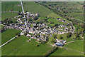
Longnor village
Aerial view of Longnor village
Image: © Richard Bird
Taken: 21 Apr 2009
0.03 miles