IMAGES TAKEN NEAR TO
Reapsmoor, BUXTON, SK17 0LL
Introduction
This page details the photographs taken nearby to Reapsmoor, SK17 0LL by members of the Geograph project.
The Geograph project started in 2005 with the aim of publishing, organising and preserving representative images for every square kilometre of Great Britain, Ireland and the Isle of Man.

There are currently over 7.5m images from over14,400 individuals and you can help contribute to the project by visiting https://www.geograph.org.uk
Image Map
Images are licensed for reuse under creativecommons.org/licenses/by-sa/2.0
Notes
- Clicking on the map will re-center to the selected point.
- The higher the marker number, the further away the image location is from the centre of the postcode.
Image Listing (8 Images Found)
Images are licensed for reuse under creativecommons.org/licenses/by-sa/2.0
Image
Details
Distance
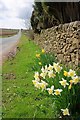
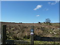
3
Field near Spout Farm
Spout Farm is in the distance.
This field in spite of being very rough pasture and boundary by a ruined wall (off photo to the right) is not Open Access land. Strange.
Image: © Mick Garratt
Taken: 2 Apr 2011
0.13 miles
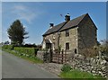
4
Farmhouses in the Staffordshire Moorlands
Moorland about two miles south of Longnor, and west of Sheen.
Image: © Peter Barr
Taken: 22 Mar 2011
0.16 miles
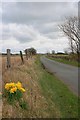
5
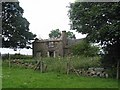
Ruined farm
Ruined farm on Reaps Moor almost slap-bang in the middle of the square.
Image: © Dennis Thorley
Taken: 8 Jul 2005
0.19 miles
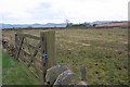
6
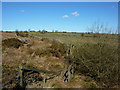
Footbridge over a small gully
On scrubby farmland south of Reaps Moor, Staffordshire.
Image: © Peter Barr
Taken: 22 Mar 2011
0.21 miles
7
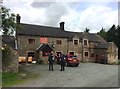
Ye Olde Butchers Arms at Reaps Moor
Image: © Jonathan Clitheroe
Taken: 6 Aug 2017
0.23 miles