IMAGES TAKEN NEAR TO
Longnor, BUXTON, SK17 0LF
Introduction
This page details the photographs taken nearby to SK17 0LF by members of the Geograph project.
The Geograph project started in 2005 with the aim of publishing, organising and preserving representative images for every square kilometre of Great Britain, Ireland and the Isle of Man.

There are currently over 7.5m images from over14,400 individuals and you can help contribute to the project by visiting https://www.geograph.org.uk
Image Map
Images are licensed for reuse under creativecommons.org/licenses/by-sa/2.0
Notes
- Clicking on the map will re-center to the selected point.
- The higher the marker number, the further away the image location is from the centre of the postcode.
Image Listing (8 Images Found)
Images are licensed for reuse under creativecommons.org/licenses/by-sa/2.0
Image
Details
Distance
1
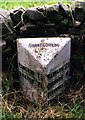
Old Milepost by the B5053, Ridge Farm, Fawfieldhead Parish
Cast iron post by the B5053, in parish of FAWFIELDHEAD (STAFFORDSHIRE MOORLANDS District), Ridge Farm, on the verge in front of drystone wall, on West side of road, near field gate. Lathe iron casting, erected by the County Council in the 19th/20th century.
Inscription reads:-
: LONGNOR 1½ / BUXTON 7½ : : FAWFIELDHEAD : : WARSLOW 2¾ / ONECOTE 6 / IPSTONES 10 / FROGHALL 12 / CHEADLE 13 :
Maker:-
: Chas. Lathe, Tipton. :
Staffordshire HER listed
HER Number: 20643 https://www.heritagegateway.org.uk/Gateway/Results_Single.aspx?uid=MST5909&resourceID=1010
Milestone Society National ID: ST_CDBX15.
Image: © J Higgins
Taken: 1 Jan 2000
0.03 miles
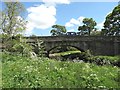
3
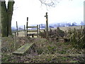
Stile and footbridge
The farm beyond is called The Low.
Image: © Marion Phillips
Taken: 15 Mar 2010
0.20 miles
4
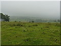
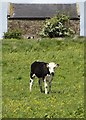
Misty day at The Low
Cattle can just be seen grazing at this farm near Fawfieldhead.
Image: © Peter Barr
Taken: 22 Jul 2010
0.22 miles
5
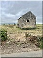
Old barn
An old barn, the gate way appears to be blocked to prevent unauthorised access.
Image: © Jay Pea
Taken: 4 Sep 2022
0.24 miles
7
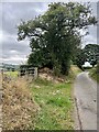
Down the lane
Looking south east down the lane.
Image: © Jay Pea
Taken: 4 Sep 2022
0.25 miles
8
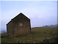
Stone barn
Unused barn with cattle housing below and hayloft over. On the right you can see an ancient mound.
Image: © Marion Phillips
Taken: 15 Mar 2010
0.25 miles