IMAGES TAKEN NEAR TO
Hulme End, BUXTON, SK17 0HF
Introduction
This page details the photographs taken nearby to SK17 0HF by members of the Geograph project.
The Geograph project started in 2005 with the aim of publishing, organising and preserving representative images for every square kilometre of Great Britain, Ireland and the Isle of Man.

There are currently over 7.5m images from over14,400 individuals and you can help contribute to the project by visiting https://www.geograph.org.uk
Image Map
Images are licensed for reuse under creativecommons.org/licenses/by-sa/2.0
Notes
- Clicking on the map will re-center to the selected point.
- The higher the marker number, the further away the image location is from the centre of the postcode.
Image Listing (45 Images Found)
Images are licensed for reuse under creativecommons.org/licenses/by-sa/2.0
Image
Details
Distance
1
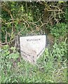
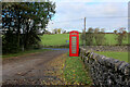
Old Milepost by the B5054, Cawlow Farm, Warslow and Elkstones Parish
Cast iron post by the B5054, in parish of WARSLOW AND ELKSTONES (STAFFORDSHIRE MOORLANDS District), West of Hulme End, on grass in front of hedge, on South side of road. Lathe iron casting, erected by the County Council in the 19th/20th century. An earlier photograph can be found here https://www.geograph.org.uk/photo/6044283.
Inscription reads:- : WARSLOW 1 / LEEK 9 : : WARSLOW : : HARTINGTON 2 / ALSTONFIELD 3¼ / ASHBOURNE 10¾ : : Chas. Lathe, Tipton. :
Milestone Society National ID: ST_LKHT09.
Image: © Nigel Upton
Taken: 1 May 2022
0.01 miles
2
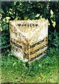
Old Milepost by the B5054, Cawlow Farm, Warslow and Elkstones Parish
Cast iron post by the B5054, in parish of WARSLOW AND ELKSTONES (STAFFORDSHIRE MOORLANDS District), West of Hulme End, on grass in front of hedge, on South side of road. Lathe iron casting, erected by the County Council in the 19th/20th century.
Inscription reads:- : WARSLOW 1 / LEEK 9 : : WARSLOW : : HARTINGTON 2 / ALSTONFIELD 3¼ / ASHBOURNE 10¾ : : Chas. Lathe, Tipton. :
Milestone Society National ID: ST_LKHT09.
Image: © J Higgins
Taken: Unknown
0.01 miles
3
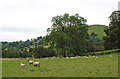
Cowlow Farm, Warslow
Cowlow Farm, Warslow - view across the Manifold Valley.
Image: © Mike Harris
Taken: 4 Aug 2007
0.02 miles
4
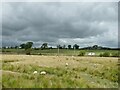
Sheep at Cowlow
Modern maps call it Cawlow, but older maps use the spelling Cowlow.
Image: © Stephen Craven
Taken: 29 Aug 2022
0.07 miles
5
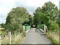
Bridge on the rail trail at Hulme End
The modern footbridge crosses, not a stream but an underpass for livestock from the appropriately named farm at Cowlow.
Image: © Stephen Craven
Taken: 29 Aug 2022
0.10 miles
6
Once were trains
The trackbed of the dismantled Leek & Manifold Valley Light Railway. The railway opened in 1904 and closed in 1934 becoming a 'National Pedestrian Path' in 1937.
Image: © Michael Dibb
Taken: 26 Jun 2018
0.13 miles
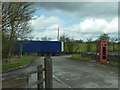
8
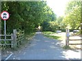
Telephone Kiosk at Hulme End
Located in the car park that serves the Manifold Valley Visitor Centre.
It looks in better repair than in 2012.
Image]
Image: © Chris Heaton
Taken: 3 Nov 2021
0.13 miles
9
Phone box, strapped up
The remnants of a telephone box, at Hulme End car park.
Image: © Peter Barr
Taken: 17 Apr 2012
0.14 miles
10
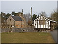
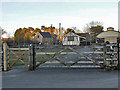
Manifold Railway Station at Hulme End
Manifold Railway Station, visitor centre for the Manifold Valley.
Image: © SMJ
Taken: 5 Mar 2010
0.15 miles