IMAGES TAKEN NEAR TO
Hyde Street, DUKINFIELD, SK16 5NS
Introduction
This page details the photographs taken nearby to Hyde Street, SK16 5NS by members of the Geograph project.
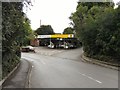
The Geograph project started in 2005 with the aim of publishing, organising and preserving representative images for every square kilometre of Great Britain, Ireland and the Isle of Man.

There are currently over 7.5m images from over14,400 individuals and you can help contribute to the project by visiting https://www.geograph.org.uk
Image Map
Images are licensed for reuse under creativecommons.org/licenses/by-sa/2.0
Notes
- Clicking on the map will re-center to the selected point.
- The higher the marker number, the further away the image location is from the centre of the postcode.
Image Listing (59 Images Found)
Images are licensed for reuse under creativecommons.org/licenses/by-sa/2.0
Image
Details
Distance
1
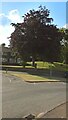
Dukinfield, Tameside
Tree back from main road to Morrisons.
Image: © Andrew Burrows
Taken: 16 Jun 2023
0.02 miles
2
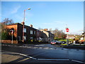
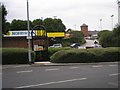
Hyde Street ? Dukinfield
View to Hyde Street at the junction with Oxford Road (B6175). Hyde Street is one way coming up from Sandy Lane.
Image: © John Topping
Taken: 16 Dec 2012
0.02 miles
3
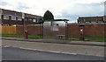
Bus Stop and Post Box on Oxford Road
The E II R post box (SK16 70) is a wall-box with a brick surround.
Image: © Gerald England
Taken: 11 Aug 2014
0.03 miles
4
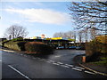
Morrisons Petrol Station ? Dukinfield
Exit onto Sandy Lane.
Image: © John Topping
Taken: 16 Dec 2012
0.04 miles
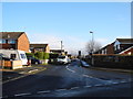
5
Sandy Lane
The top of Sandy Lane leading off Oxford Road.
Image: © Gerald England
Taken: 2 May 2012
0.05 miles
6
Filling Station at Dukinfield Morrisons
The filling station is tucked away from the main supermarket by the exit on to Sandy Lane.
Image: © Gerald England
Taken: 11 Aug 2014
0.06 miles
7
Foundry Street
A cut-off portion of Foundry Street accessible only from Oxford Road. Behind the hedges on the left is Morrisons supermarket.
Image: © Gerald England
Taken: 27 Jul 2010
0.07 miles
8
Vicarage Drive ? Dukinfield
Vicarage Drive, (off Lodge Lane) leading to St. John’s Church (SJ9597).
Image: © John Topping
Taken: 16 Dec 2012
0.07 miles
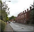
9

Shops on Lodge Lane ? Dukinfield
Pisces Hair Studio and Welcome (off licence & convenience) Store.
Image: © John Topping
Taken: 16 Dec 2012
0.07 miles
10
Sandy Lane
The top of Sandy Lane, Dukinfield, with the petrol station and Morrisons supermarket behind.
Image: © Gerald England
Taken: 31 Jul 2008
0.08 miles