IMAGES TAKEN NEAR TO
Shelley Rise, DUKINFIELD, SK16 5EF
Introduction
This page details the photographs taken nearby to Shelley Rise, SK16 5EF by members of the Geograph project.
The Geograph project started in 2005 with the aim of publishing, organising and preserving representative images for every square kilometre of Great Britain, Ireland and the Isle of Man.

There are currently over 7.5m images from over14,400 individuals and you can help contribute to the project by visiting https://www.geograph.org.uk
Image Map
Images are licensed for reuse under creativecommons.org/licenses/by-sa/2.0
Notes
- Clicking on the map will re-center to the selected point.
- The higher the marker number, the further away the image location is from the centre of the postcode.
Image Listing (26 Images Found)
Images are licensed for reuse under creativecommons.org/licenses/by-sa/2.0
Image
Details
Distance
2
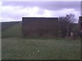
The Old 13th Cheshire Astley Volunteer Rifle Corps firing range
The former target wall of the Astley Volunteer Rifle Corps. The unit itself (what we would call today a "Territorial Army" unit) was Dukinfield-based and lent its name to "The Old Thirteenth Cheshire Astley Volunteer Rifleman Corps Inn" in Stalybridge, the longest pub name in the UK.
Image: © Tom Hindley
Taken: 3 Jan 2012
0.11 miles
3
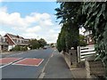
Tennyson Avenue
On the Broadbent Fold estate.
Image: © Gerald England
Taken: 3 Aug 2009
0.12 miles
4
Hough Hill
Hough Hill is used to graze horses. Looking down on Bower Fold, home of Stalybridge Celtic FC
Image: © Richard Webb
Taken: 21 Jul 2004
0.16 miles
5
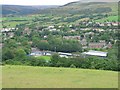
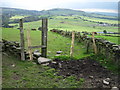
Bridleway on Hough Hill
Looking north towards Stalybridge though most of it is still hidden in the valley. Hartshead Pike can be seen left centre.
Image: © Bill Boaden
Taken: 19 May 2010
0.16 miles
6
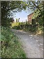
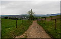
Range Road (track), Dukinfield
Leading to Hough Hill and Bardsley Fold Farm (both SJ9697) from Yew Tree Lane.
Image: © John Topping
Taken: 17 Oct 2013
0.18 miles
7
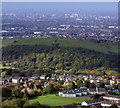
Hough Hill
Hough Hill can be seen in the middle distance, with tree lined lower slopes giving way to grazing land towards the summit. Stalyhill School in the outskirts of Stalybridge can be seen in the foreground,the children are looking at a space rocket in the playground. Greater Manchester spreads out to the horizon; if the image is viewed in its larger sizes you can see some of Manchester’s landmarks including Beetham Tower the tallest building in England outside London and the Etihad Stadium home of Manchester City FC the premier league champions.
Image: © Stephen Burton
Taken: 17 Oct 2012
0.18 miles
9

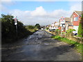
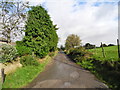
Dukinfield, Yew Tree Lane
The top of Yew Tree Lane where it changes from a track to a "proper" road.
Image: © David Dixon
Taken: 10 Nov 2012
0.18 miles