IMAGES TAKEN NEAR TO
Dryden Close, DUKINFIELD, SK16 5EA
Introduction
This page details the photographs taken nearby to Dryden Close, SK16 5EA by members of the Geograph project.
The Geograph project started in 2005 with the aim of publishing, organising and preserving representative images for every square kilometre of Great Britain, Ireland and the Isle of Man.

There are currently over 7.5m images from over14,400 individuals and you can help contribute to the project by visiting https://www.geograph.org.uk
Image Map (Loading...)


Getting Data...Please wait
Leaflet Map data © OpenStreetMap
Images are licensed for reuse under creativecommons.org/licenses/by-sa/2.0
Notes
- Clicking on the map will re-center to the selected point.
- The higher the marker number, the further away the image location is from the centre of the postcode.
Image Listing (27 Images Found)
Images are licensed for reuse under creativecommons.org/licenses/by-sa/2.0
Image
Details
Distance
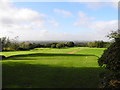
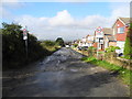
1
Range Road (track), Dukinfield
Leading to Hough Hill and Bardsley Fold Farm (both SJ9697) from Yew Tree Lane.
Image: © John Topping
Taken: 17 Oct 2013
0.09 miles
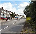
2
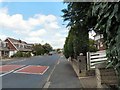
Tennyson Avenue
On the Broadbent Fold estate.
Image: © Gerald England
Taken: 3 Aug 2009
0.09 miles
4

Dukinfield, Yew Tree Lane
The top of Yew Tree Lane where it changes from a track to a "proper" road.
Image: © David Dixon
Taken: 10 Nov 2012
0.09 miles
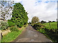
6
The Top of Yew Tree Lane
Beyond the end of the modern houses, Yew Tree Lane turns into a rough track leading to Early Bank Road.
Image: © Gerald England
Taken: 3 Aug 2009
0.11 miles
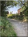
7

Dukinfield, Yew Tree Lane (Track)
After passing Dukinfield Golf Club, Yew Tree Lane changes into a track.
Image: © David Dixon
Taken: 10 Nov 2012
0.12 miles
8
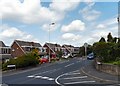
Tennyson Avenue
On the Broadbent Fold estate.
Image: © Gerald England
Taken: 3 Aug 2009
0.12 miles