IMAGES TAKEN NEAR TO
Astley Street, DUKINFIELD, SK16 4QW
Introduction
This page details the photographs taken nearby to Astley Street, SK16 4QW by members of the Geograph project.
The Geograph project started in 2005 with the aim of publishing, organising and preserving representative images for every square kilometre of Great Britain, Ireland and the Isle of Man.

There are currently over 7.5m images from over14,400 individuals and you can help contribute to the project by visiting https://www.geograph.org.uk
Image Map
Images are licensed for reuse under creativecommons.org/licenses/by-sa/2.0
Notes
- Clicking on the map will re-center to the selected point.
- The higher the marker number, the further away the image location is from the centre of the postcode.
Image Listing (84 Images Found)
Images are licensed for reuse under creativecommons.org/licenses/by-sa/2.0
Image
Details
Distance
1
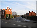
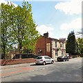
Chapel Street - Dukinfield
Chapel Street (west end) at the junction with Astley Street (B6169). Old Chapel Church (SJ9497) can be seen on Chapel Hill at the eastern end of Chapel Street.
Image: © John Topping
Taken: 12 Dec 2012
0.05 miles
2
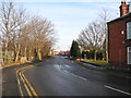
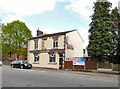
B6169 Astley Street - Dukinfield
Astley Street looking northeast from the bend between Chapel Street and Smith Street (next right).
Image: © John Topping
Taken: 12 Dec 2012
0.07 miles
3
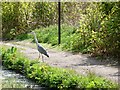
Towpath angler
This heron only flew off when our boat's bows were nearly alongside it.
Image: © Christine Johnstone
Taken: 17 May 2010
0.09 miles
4
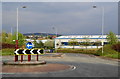
Fifth Avenue, Dukinfield
This is where it begins off Astley Street. The industrial development is built on the site of the old Dewsnap Sidings.
Image: © Bill Boaden
Taken: 4 May 2010
0.10 miles
5
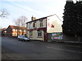
Astley Arms
A freehouse on Astley Street known locally as Bottom Astley Image
Image: © Gerald England
Taken: 14 May 2016
0.11 miles
6
Bottom Astley
The Astley Arms on Astley Street is known as Bottom Astley to distinguish it from the Astley Arms Image on Chapel Hill which is known as Top Astley.
Image: © Gerald England
Taken: 14 May 2016
0.11 miles
7
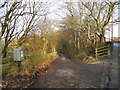
Track down to Plantation Farm
Track leading to Plantation Farm, off Astley Street with the footpath sign for the Peak Forest Canal and Portland Basin (SJ9398).
Image: © John Topping
Taken: 12 Dec 2012
0.11 miles
8
Astley Arms (Bottom Astley) - Dukinfield
The Astley Arms on Astley Street (B6169). This pub is known locally as bottom Astley.
Image: © John Topping
Taken: 12 Dec 2012
0.11 miles
9
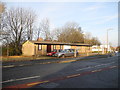
Pre- Fabricated Bungalows
Post War pre-fabricated Bungalows on Astley Street, Dukinfield.
Image: © John Topping
Taken: 12 Dec 2012
0.12 miles
10
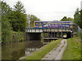
Peak Forest Canal, Bridge#1B
A Northern Rail local train crosses the Peak Forest Canal at bridge#1B.
Image: © David Dixon
Taken: 27 May 2013
0.12 miles