IMAGES TAKEN NEAR TO
Rock Terrace, DUKINFIELD, SK16 4HD
Introduction
This page details the photographs taken nearby to Rock Terrace, SK16 4HD by members of the Geograph project.
The Geograph project started in 2005 with the aim of publishing, organising and preserving representative images for every square kilometre of Great Britain, Ireland and the Isle of Man.

There are currently over 7.5m images from over14,400 individuals and you can help contribute to the project by visiting https://www.geograph.org.uk
Image Map
Images are licensed for reuse under creativecommons.org/licenses/by-sa/2.0
Notes
- Clicking on the map will re-center to the selected point.
- The higher the marker number, the further away the image location is from the centre of the postcode.
Image Listing (136 Images Found)
Images are licensed for reuse under creativecommons.org/licenses/by-sa/2.0
Image
Details
Distance
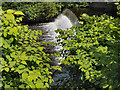
1
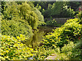
River Tame, Dukinfield
Looking upstream from Riverside at Dukinfield.
Image: © David Dixon
Taken: 4 Jun 2011
0.01 miles
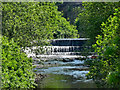
2
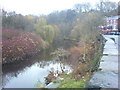
River Tame
Looking upstream from Riverside towards Park Road. Houses of Rock Terrace to the right.
Image: © Keith Williamson
Taken: 27 Nov 2007
0.03 miles
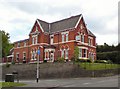
3
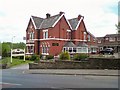
Barton Villa Hotel
On Crescent Road, Dukinfield.
Image: © Gerald England
Taken: 20 May 2010
0.05 miles
6
Barton Villa Hotel
On Crescent Road, Dukinfield.
Image: © Gerald England
Taken: 20 May 2010
0.06 miles
8

Barton Villa Guest House - Crescent Road
Image: © Anthony Parkes
Taken: 29 Sep 2010
0.06 miles
9
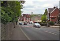
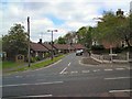
Crescent Road
The B6170 through Dukinfield.
Image: © Gerald England
Taken: 20 May 2010
0.07 miles
10
Crescent Close
A cul-de-sac off Crescent Road, Dukinfield.
Image: © Gerald England
Taken: 20 May 2010
0.09 miles