IMAGES TAKEN NEAR TO
Hall Green Close, DUKINFIELD, SK16 4EX
Introduction
This page details the photographs taken nearby to Hall Green Close, SK16 4EX by members of the Geograph project.
The Geograph project started in 2005 with the aim of publishing, organising and preserving representative images for every square kilometre of Great Britain, Ireland and the Isle of Man.

There are currently over 7.5m images from over14,400 individuals and you can help contribute to the project by visiting https://www.geograph.org.uk
Image Map
Images are licensed for reuse under creativecommons.org/licenses/by-sa/2.0
Notes
- Clicking on the map will re-center to the selected point.
- The higher the marker number, the further away the image location is from the centre of the postcode.
Image Listing (184 Images Found)
Images are licensed for reuse under creativecommons.org/licenses/by-sa/2.0
Image
Details
Distance
1
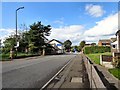
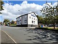
Crescent Road
The B6170 https://www.sabre-roads.org.uk/wiki/index.php?title=B6170 on the eastern edge of Dukinfield.
The bus stop on the left is outside Dukinfield Congregational Church Image
The former Old General Image on the corner of Astley Street Image is now the offices of Leisure Technical Consultants Ltd an amusement ride inspection & certificate inspection company.
Image: © Gerald England
Taken: 8 Sep 2017
0.04 miles
2
Crescent Road
The B6170 into Ashton viewed from the top deck of a bus near Astley Street Image The Ikea warehouse Image in Image dominates the skyline.
Image: © Gerald England
Taken: 3 Jun 2010
0.04 miles
3
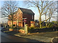
Dukinfield Congregational Church, Crescent Road
Dukinfield Congregational Church lies between Crescent Road and Zetland Street and was opened in 1911. The church also has a second site on Dewsnap Lane Image http://www.dukinfieldcc.org.uk/page26.html
Image: © Gerald England
Taken: 8 Sep 2017
0.05 miles
4
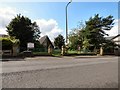
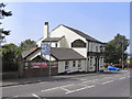
Dukinfield Masonic Hall
Weymouth Villa. Situated at the junction of Astley Street, Old Road and Hall Green Road.
Image: © Keith Williamson
Taken: 20 Dec 2007
0.05 miles
5
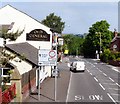
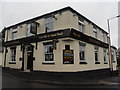
Old General
Old General Public house, Crescent Road, Dukinfield.
Image: © David Dixon
Taken: 4 Jun 2011
0.05 miles
6
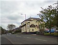
Old General
On the corner of Astley Street and Crescent Road.
Image: © Gerald England
Taken: 20 May 2010
0.06 miles
7
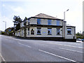
Old General, Dukinfield
The Old General public house at the corner of Crescent Road and Astley Street, in Dukinfield.
Image: © David Dixon
Taken: 4 Jun 2011
0.06 miles
8
Former Old General
The former Old General Image on the corner of Astley Street and Crescent Road is now the offices of Leisure Technical Consultants Ltd an amusement ride inspection & certificate inspection company. Built in 1807 it was the oldest pub in Dukinfield.
Image: © Gerald England
Taken: 8 Sep 2017
0.06 miles
10
Dukinfield Congregational Church
Dukinfield Congregational Church lies between Crescent Road and Zetland Street and was opened in 1911. The church also has a second site on Dewsnap Lane Image http://www.dukinfieldcc.org.uk/page26.html
Image: © Gerald England
Taken: 31 May 2016
0.06 miles