IMAGES TAKEN NEAR TO
Combermere Street, DUKINFIELD, SK16 4DP
Introduction
This page details the photographs taken nearby to Combermere Street, SK16 4DP by members of the Geograph project.
The Geograph project started in 2005 with the aim of publishing, organising and preserving representative images for every square kilometre of Great Britain, Ireland and the Isle of Man.

There are currently over 7.5m images from over14,400 individuals and you can help contribute to the project by visiting https://www.geograph.org.uk
Image Map
Images are licensed for reuse under creativecommons.org/licenses/by-sa/2.0
Notes
- Clicking on the map will re-center to the selected point.
- The higher the marker number, the further away the image location is from the centre of the postcode.
Image Listing (188 Images Found)
Images are licensed for reuse under creativecommons.org/licenses/by-sa/2.0
Image
Details
Distance
1
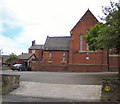
St Mary's Church
St Mary's Roman Catholic Church in Combermarle Street.
Image: © Gerald England
Taken: 20 May 2010
0.01 miles
2
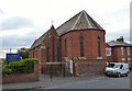
St Mary's, Dukinfield
St Mary's, Dukinfield is in the Catholic Diocese of Shrewsbury. Since 2015 it has joined with the parish of St Paul's, Hyde under the pastoral care of Fr Oliver O'Doherty. http://www.stmaryandstpaul.org.uk/
The church on Zetland Street was built in 1848 replacing the original church at the junction of Astley Street and Railway Street which had to close due to mining subsidence.
Image: © Gerald England
Taken: 31 May 2016
0.03 miles
3
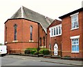
St Mary's Dukinfield
St Mary's, Dukinfield is in the Catholic Diocese of Shrewsbury. Since 2015 it has joined with the parish of St Paul's, Hyde under the pastoral care of Fr Oliver O'Doherty. http://www.stmaryandstpaul.org.uk/
The church on Zetland Street was built in 1848 replacing the original church at the junction of Astley Street and Railway Street which had to close due to mining subsidence.
Image: © Gerald England
Taken: 31 May 2016
0.04 miles
5
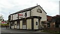
Newborough Inn
On the corner of Astley Street and Zetland Street.
Image
Image: © Gerald England
Taken: 20 May 2010
0.05 miles
6
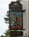
Sign of Newborough Inn
The sign for the Newborough Inn Image
Image: © Gerald England
Taken: 20 May 2010
0.05 miles
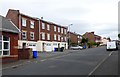
7
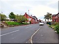
Zetland Street
Off Astley Street. The building on the left is Dukinfield Congregational Church Image
Image: © Gerald England
Taken: 31 May 2016
0.05 miles
8
Newborough Inn
On the corner of Astley Street and Zetland Street.
Image: © Gerald England
Taken: 20 May 2010
0.06 miles
9
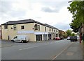
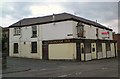
Astley Street
The former Hydes pub the Newborough Inn Image at 31 Astley Street is now the Raja Bros Extra convenience store. For now it still carries the old inn sign Image
Image: © Gerald England
Taken: 31 May 2016
0.06 miles
10
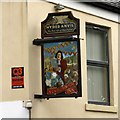
Sign of the Newborough Inn
Although the former Hydes pub the Newborough Inn Image at 31 Astley Street is now the Raja Bros Extra convenience store Image, it still carries the old inn sign for now.
Image: © Gerald England
Taken: 31 May 2016
0.06 miles