IMAGES TAKEN NEAR TO
Armadale Road, DUKINFIELD, SK16 4BD
Introduction
This page details the photographs taken nearby to Armadale Road, SK16 4BD by members of the Geograph project.
The Geograph project started in 2005 with the aim of publishing, organising and preserving representative images for every square kilometre of Great Britain, Ireland and the Isle of Man.

There are currently over 7.5m images from over14,400 individuals and you can help contribute to the project by visiting https://www.geograph.org.uk
Image Map (Loading...)


Getting Data...Please wait
Leaflet Map data © OpenStreetMap
Images are licensed for reuse under creativecommons.org/licenses/by-sa/2.0
Notes
- Clicking on the map will re-center to the selected point.
- The higher the marker number, the further away the image location is from the centre of the postcode.
Image Listing (6 Images Found)
Images are licensed for reuse under creativecommons.org/licenses/by-sa/2.0
Image
Details
Distance
1

Bunting with flag of Greater Manchester
Bunting made up of the county flag of Greater Manchester, flying in Dukinfield, Tameside.
Image: © Steven Haslington
Taken: 7 Mar 2011
0.19 miles

3

Boyd's Walk - Dukinfield
At the junction with Birch Lane (B6170).
Image: © John Topping
Taken: 16 Dec 2012
0.23 miles
4

Doctors? Surgery
On Birch Lane (B6170), Dukinfield.
Image: © John Topping
Taken: 16 Dec 2012
0.24 miles
5
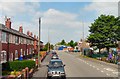
Jeffrey Avenue
From the top deck of a bus.
Image: © Gerald England
Taken: 3 Jun 2010
0.24 miles
6

Kia Motors - Dukinfield
On Birch Lane (B6170).
Image: © John Topping
Taken: 16 Dec 2012
0.24 miles