IMAGES TAKEN NEAR TO
Milton Avenue, STALYBRIDGE, SK15 3RY
Introduction
This page details the photographs taken nearby to Milton Avenue, SK15 3RY by members of the Geograph project.
The Geograph project started in 2005 with the aim of publishing, organising and preserving representative images for every square kilometre of Great Britain, Ireland and the Isle of Man.

There are currently over 7.5m images from over14,400 individuals and you can help contribute to the project by visiting https://www.geograph.org.uk
Image Map
Images are licensed for reuse under creativecommons.org/licenses/by-sa/2.0
Notes
- Clicking on the map will re-center to the selected point.
- The higher the marker number, the further away the image location is from the centre of the postcode.
Image Listing (60 Images Found)
Images are licensed for reuse under creativecommons.org/licenses/by-sa/2.0
Image
Details
Distance
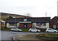
1
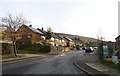
Shakespeare Avenue, Stalybridge
Looking south east.
Image: © JThomas
Taken: 8 Nov 2018
0.01 miles
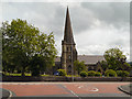
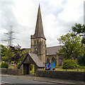
3

Lychgate, St James' Church, Millbrook
Image: © Alexander P Kapp
Taken: 28 Jun 2007
0.06 miles
4
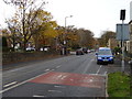
Huddersfield Road, Stalybridge
Looking south west on the B6175.
Image: © JThomas
Taken: 8 Nov 2018
0.06 miles
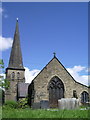
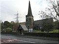
5
The Church of St James, Millbrook
St James' Church, on Huddersfield Road, dates from the mid-nineteenth century.
Image: © David Dixon
Taken: 27 Jun 2012
0.06 miles
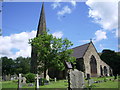
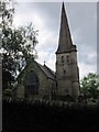
7
St James Millbrook
St James' Church, Huddersfield Road, Millbrook.
Image: © Gerald England
Taken: 31 Oct 2008
0.07 miles