IMAGES TAKEN NEAR TO
Green Hollow Fold, STALYBRIDGE, SK15 3RP
Introduction
This page details the photographs taken nearby to Green Hollow Fold, SK15 3RP by members of the Geograph project.
The Geograph project started in 2005 with the aim of publishing, organising and preserving representative images for every square kilometre of Great Britain, Ireland and the Isle of Man.

There are currently over 7.5m images from over14,400 individuals and you can help contribute to the project by visiting https://www.geograph.org.uk
Image Map
Images are licensed for reuse under creativecommons.org/licenses/by-sa/2.0
Notes
- Clicking on the map will re-center to the selected point.
- The higher the marker number, the further away the image location is from the centre of the postcode.
Image Listing (40 Images Found)
Images are licensed for reuse under creativecommons.org/licenses/by-sa/2.0
Image
Details
Distance
1
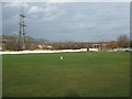
Stayley Cricket Club - Ground
Looking across Stayley CC's Oxford Street ground in Millbrook, Stalybridge.
Image: © BatAndBall
Taken: 22 Nov 2012
0.11 miles
2
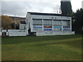
Stayley Cricket Club - Pavilion
Stayley CC run two teams in the Saddleworth & District Cricket League.
Image: © BatAndBall
Taken: 22 Nov 2012
0.14 miles
3
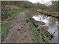
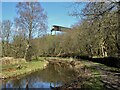
Damage to towpath on Huddersfield Narrow Canal
Within the last week water had cascaded down the hillside, tearing out a large amount of debris that is now in the canal
Image: © Chris Morgan
Taken: 18 Mar 2019
0.16 miles
4
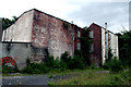
Millbrook, Cheshire: Spring-grove Woollen Mill
This derelict building is the remains of Spring-Grove Woollen Mill. When it closed is not known to me.
Image: © Dr Neil Clifton
Taken: 10 Jul 2010
0.16 miles
5

Oakwood Mill, Millbrook, near Stalybridge
This is a very ruinous mill that is part demolished. Built 1851 and re-engined 1908 with an engine house behind the closest building. The engine house has white glazed bricks internally but is otherwise completely ruined.
Image: © Chris Allen
Taken: 13 Feb 2010
0.16 miles
6
Abandoned Engineering
High above the Huddersfield Narrow Canal a classic piece of abandoned engineering. Apparently this was a conveyor to carry coal across from railway sidings to power station.
The conveyor would have crossed the canal and the parallel River Tame
Image: © Kevin Waterhouse
Taken: 3 Apr 2023
0.17 miles
7
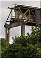
Derelict Conveyor
Derelict conveyor, presumably part of the old Hartshead Power Station.
Image: © Peter McDermott
Taken: 26 Jun 2017
0.17 miles
8
Staley & Millbrook Viaduct site
The site of Staley & Millbrook Railway Viaduct. Staley & Millbrook Railway Station was an LNWR station on the Micklehurst Line, which was open to passengers from 3rd May 1886 to 1st November 1909. By the 1970's, the railway line itself had been mostly removed, save for a small branch leading to a local power station.
Image: © Tom Hindley
Taken: 18 May 2012
0.18 miles
9
Site of Staley & Millbrook Railway Station 1
The site of Staley & Millbrook Railway Station, an LNWR station on the Micklehurst Line, which was open to passengers from 3rd May 1886 to 1st November 1909. By the 1970's, the railway line itself had been mostly removed, save for a small branch leading to a local power station.
Image: © Tom Hindley
Taken: 18 May 2012
0.19 miles
10
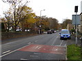
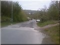
Huddersfield Road, Stalybridge
Looking south west on the B6175.
Image: © JThomas
Taken: 8 Nov 2018
0.19 miles