IMAGES TAKEN NEAR TO
Castle Lane, STALYBRIDGE, SK15 3PA
Introduction
This page details the photographs taken nearby to Castle Lane, SK15 3PA by members of the Geograph project.
The Geograph project started in 2005 with the aim of publishing, organising and preserving representative images for every square kilometre of Great Britain, Ireland and the Isle of Man.

There are currently over 7.5m images from over14,400 individuals and you can help contribute to the project by visiting https://www.geograph.org.uk
Image Map
Images are licensed for reuse under creativecommons.org/licenses/by-sa/2.0
Notes
- Clicking on the map will re-center to the selected point.
- The higher the marker number, the further away the image location is from the centre of the postcode.
Image Listing (66 Images Found)
Images are licensed for reuse under creativecommons.org/licenses/by-sa/2.0
Image
Details
Distance
1
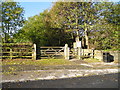
Carrbrook Heritage Trail
Entrance off Castle Lane.
Image: © John Topping
Taken: 4 Nov 2013
0.02 miles
3
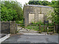
Entrance to Cowbury Green
The entrance to Cowbury Green, part of the Stalybridge Country Park.
Image: © David Dixon
Taken: 27 Jun 2012
0.04 miles
4
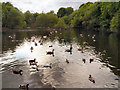
Duck Island, Carrbrook
Although there is an island in it, Duck Island is the name of the village duck pond. It was originally built as a lodge for the old Buckton Vale Print Works. A variety of bird life may be spotted on the water including Mallards, Aylesbury Ducks, Brent and Canada Geese.
Image: © David Dixon
Taken: 27 Jun 2012
0.04 miles
5
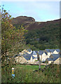
Pennine Bridleway, Carrbrook
A view north from the National Trail where it descends into the valley of Carr Brook to the southeast of Mossley. The new housing has been built on a former industrial site. Buckton Vale Quarry can be seen on the skyline.
Image: © michael ely
Taken: 27 Sep 2007
0.04 miles
6
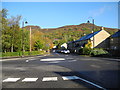
Castle Lane, Carrbrook
Mini-roundabout with South View (L) and Calico Crescent (R). Buckton Vale Quarry (SD9901) on the skyline.
Image: © John Topping
Taken: 4 Nov 2013
0.05 miles
7
Calico Crescent
A glimpse from Carbrook Recreation Ground of new houses built on the site of a former factory.
Image: © Gerald England
Taken: 25 May 2009
0.05 miles
8
Castle Lane, Carrbrook (1)
Bowling Green on the left.
Image: © John Topping
Taken: 4 Nov 2013
0.05 miles
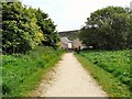
9
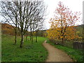
Path, Cowbury Green, Carrbrook
Part of the Stalybridge Country Park.
Image: © JThomas
Taken: 8 Nov 2018
0.06 miles
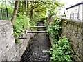
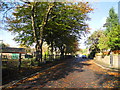
10
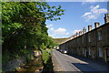
Long Row
A fine terrace. The stream on the left is Carr Brook, in one of its less impressive modes.
Image: © Bill Boaden
Taken: 15 Jun 2010
0.06 miles