IMAGES TAKEN NEAR TO
Fistral Crescent, STALYBRIDGE, SK15 3HN
Introduction
This page details the photographs taken nearby to Fistral Crescent, SK15 3HN by members of the Geograph project.
The Geograph project started in 2005 with the aim of publishing, organising and preserving representative images for every square kilometre of Great Britain, Ireland and the Isle of Man.

There are currently over 7.5m images from over14,400 individuals and you can help contribute to the project by visiting https://www.geograph.org.uk
Image Map
Images are licensed for reuse under creativecommons.org/licenses/by-sa/2.0
Notes
- Clicking on the map will re-center to the selected point.
- The higher the marker number, the further away the image location is from the centre of the postcode.
Image Listing (47 Images Found)
Images are licensed for reuse under creativecommons.org/licenses/by-sa/2.0
Image
Details
Distance
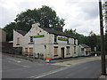
1
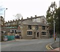
Royal Oak, Millbrook
The Royal Oak was recorded as an alehouse in 1789 when it was kept by William Swallow. This was four years before the turnpike road (now the B6175) in the foreground was constructed. Although a very popular pub for many years and known for its food, it closed around 2010. In September 2011 it was sold at auction for £80,000 and it is currently undergoing renovation. The houses in the background are on Grafton Street.
Image
Image: © Gerald England
Taken: 24 Oct 2012
0.06 miles
2
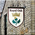
Sign of the Royal Oak
Sign for the Royal Oak Image
Image: © Gerald England
Taken: 24 Oct 2012
0.06 miles
3
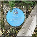
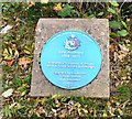
Blue plaque: Jethro Tinker (1788-1871)
Blue plaque to local naturalist Jethro Tinker http://www.tameside.gov.uk/blueplaque/jethrotinker This is one of two blue plaques Image unveiled at the Millbrook entrance Image to Stalybridge Country Park in November 1995. They are now almost hidden under by the roadside fence.
There is a monument to Jethro Tinker in Stamford Park Image
Image: © Gerald England
Taken: 24 Oct 2012
0.09 miles
4
Huddersfield Road from Stalybridge Country Park
Stone dwellings on Huddersfield Road are seen here from the Millbrook part of Stalybridge Country Park, in Stalybridge, Greater Manchester, England.
Image: © Steven Haslington
Taken: 6 May 2013
0.09 miles
5
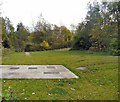
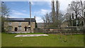
Stalybridge Country Park
From the entrance off Huddersfield Road, Millbrook.
Image: © Gerald England
Taken: 24 Oct 2012
0.09 miles
6
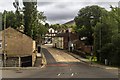
Millbrook
The B6175, Huddersfield Road at Millbrook.
Image: © Peter McDermott
Taken: 29 Aug 2015
0.10 miles
7
Blue plaque: John Bradbury (1768-1825)
A blue plaque at Stalybridge Country Park commemorating local born botanist John Bradbury http://www.tameside.gov.uk/blueplaque/johnbradbury famed explorer of the interior of America. He was an early tutor of Stalybridge naturalist Jethro Tinker to whom another blue plaque Image was unveiled in November 1995 on the other side of the Millbrook entrance Image to Stalybridge Country Park.
Image: © Gerald England
Taken: 24 Oct 2012
0.10 miles
8
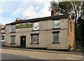
The Commercial
The Commercial on Huddersfield Road, Millbrook was founded as a beerhouse in 1873. It is currently vacant and boarded up.
Image: © Gerald England
Taken: 24 Oct 2012
0.11 miles
10
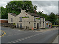
The Commercial at Millbrook
The Commercial, a closed public house at the corner of Besom Lane and Huddersfield Road. Metal shutters have appeared at the upstairs windows and have replaced the hardboard at the downstairs windows evident in Image taken 2 weeks earlier.
There is currently a picture on Google Streetview (http://goo.gl/maps/Yaxh ) dating from March 2009, which shows the pub when it was open.
Image: © David Dixon
Taken: 27 Jun 2012
0.11 miles