IMAGES TAKEN NEAR TO
Linden Road, STALYBRIDGE, SK15 2SL
Introduction
This page details the photographs taken nearby to Linden Road, SK15 2SL by members of the Geograph project.
The Geograph project started in 2005 with the aim of publishing, organising and preserving representative images for every square kilometre of Great Britain, Ireland and the Isle of Man.

There are currently over 7.5m images from over14,400 individuals and you can help contribute to the project by visiting https://www.geograph.org.uk
Image Map
Images are licensed for reuse under creativecommons.org/licenses/by-sa/2.0
Notes
- Clicking on the map will re-center to the selected point.
- The higher the marker number, the further away the image location is from the centre of the postcode.
Image Listing (9 Images Found)
Images are licensed for reuse under creativecommons.org/licenses/by-sa/2.0
Image
Details
Distance
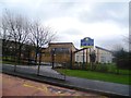
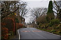
2
Burnside - A Quiet Road Near Mottram Rise
Image: © Peter Whatley
Taken: 13 Jul 2009
0.14 miles
3
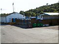
Bower Fold
Bower Fold sports and social, ancestral home of Stalybridge Celtic football club.
Image: © Roger May
Taken: 2 Sep 2005
0.16 miles
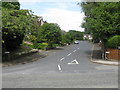
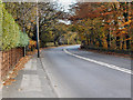
4
Mottram Old Road
Parts of this road (which feels more like a lane now) have some original old stone cottages.
Image: © Bill Boaden
Taken: 14 Dec 2009
0.16 miles
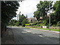
5
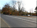
Mottram Road (A6018)
Mottram Road, at the junction with Woodend Road.
Image: © David Dixon
Taken: 17 Nov 2011
0.17 miles
6
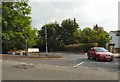
Woodend Lane
Leading to Blundering Lane.
Image: © Gerald England
Taken: 27 Jun 2009
0.18 miles
8
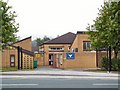
Staley Hill County Primary School
School's out! Mid-August and the usual morning throng of pupils is noticeably absent.
Image: © Roger May
Taken: 15 Aug 2005
0.23 miles