IMAGES TAKEN NEAR TO
Fern Bank Close, STALYBRIDGE, SK15 2RZ
Introduction
This page details the photographs taken nearby to Fern Bank Close, SK15 2RZ by members of the Geograph project.
The Geograph project started in 2005 with the aim of publishing, organising and preserving representative images for every square kilometre of Great Britain, Ireland and the Isle of Man.

There are currently over 7.5m images from over14,400 individuals and you can help contribute to the project by visiting https://www.geograph.org.uk
Image Map
Images are licensed for reuse under creativecommons.org/licenses/by-sa/2.0
Notes
- Clicking on the map will re-center to the selected point.
- The higher the marker number, the further away the image location is from the centre of the postcode.
Image Listing (13 Images Found)
Images are licensed for reuse under creativecommons.org/licenses/by-sa/2.0
Image
Details
Distance
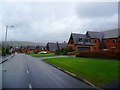
2
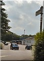
Hare and Hounds
The nearest pub to Bower Fold, home of Stalybridge Celtic.
Image: © Gerald England
Taken: 28 Jun 2009
0.13 miles
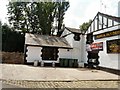
3
Hare and Hounds
The Hare and Hounds pub/restaurant on Mottram Road, to the south of Stalybridge town centre.
Image: © David Dixon
Taken: 17 Nov 2011
0.13 miles
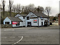
4
After the Match
The spectator at any Stalybridge Celtic football match might consider popping into this hostelry for refreshment after the game. It stands on the main road adjacent to the ground at Bower Fold.
A point-and-press shot from the rear passenger seat of a moving car - as the blurred road surface reveals.
Image: © Roger May
Taken: 21 Aug 2005
0.13 miles
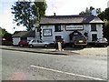
5
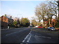
A6018 Mottram Road, Stalybridge
At the junction with Old Road.
Image: © John Topping
Taken: 13 Jan 2013
0.14 miles
6
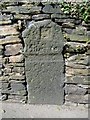
Old Milestone by Mottram Old Road, Fern Bank
Carved stone post by the UC road, in parish of Stalybridge (Tameside District), Mottram Old Road, in wall 100m North of junction with Fern Bank, on West side of road. Erected by the Manchester to Salter's Brook turnpike trust in the 18th century.
Inscription reads:-
: (9) / Miles to / (Manchester) :
Milestone Society National ID: CH_MAPE09
Image: © M Faherty
Taken: 12 Aug 2015
0.15 miles
7
Bower Fold Football Stadium
The home of Stalybridge Celtic FC.
Image: © David Dixon
Taken: 17 Nov 2011
0.19 miles
8
Bower Fold
The home of Stalybridge Celtic Football Club. http://www.stalybridgeceltic.co.uk/index.php
Image: © Gerald England
Taken: 28 Jun 2009
0.19 miles
9
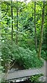
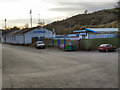
Eastwood Nature Reserve, Stalybridge, Cheshire
Image: © Andrew Burrows
Taken: 13 Jun 2023
0.20 miles
10
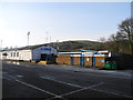
Stalybridge Celtic
Bower Fold Sports and Social Club. Hough Hill (SJ9697) in the background.
Image: © John Topping
Taken: 13 Jan 2013
0.20 miles