IMAGES TAKEN NEAR TO
Laurel Bank, STALYBRIDGE, SK15 2HN
Introduction
This page details the photographs taken nearby to Laurel Bank, SK15 2HN by members of the Geograph project.
The Geograph project started in 2005 with the aim of publishing, organising and preserving representative images for every square kilometre of Great Britain, Ireland and the Isle of Man.

There are currently over 7.5m images from over14,400 individuals and you can help contribute to the project by visiting https://www.geograph.org.uk
Image Map
Images are licensed for reuse under creativecommons.org/licenses/by-sa/2.0
Notes
- Clicking on the map will re-center to the selected point.
- The higher the marker number, the further away the image location is from the centre of the postcode.
Image Listing (12 Images Found)
Images are licensed for reuse under creativecommons.org/licenses/by-sa/2.0
Image
Details
Distance
1
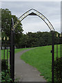
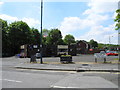
Cheetham Park, Stalybridge
A new ornate entrance at the western end of Forester Drive.
Image: © michael ely
Taken: 23 Aug 2008
0.10 miles
2
The top of Hough Hill Road
Residential properties extend quite a long way up this hill. The large building opposite is Tameside General Hospital while mill refurbishment continues in the centre of Stalybridge at the bottom of the valley.
Image: © Bill Boaden
Taken: 5 Oct 2010
0.10 miles
3
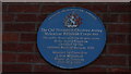
Stalybridge - Plaque to the former public house with longest name in Britain
The former 'The Old Thirteenth Cheshire Astley Volunteer Rifleman Corps Inn' had a claim to fame as being the longest pub name in Britain. It is no longer a public house but a private dwelling although this plaque remains on the building.
Image: © Colin Park
Taken: 24 Feb 2018
0.14 miles
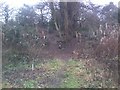
4
Hough Hill Road, Stalybridge
Hough Hill Road climbs from High Street through the town's southern suburbs. Here the road becomes a shady track as it leaves the built up area to skirt Hough Hill.
Image: © michael ely
Taken: 30 Aug 2008
0.14 miles
5
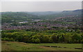
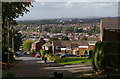
The eastern side of Stalybridge from Hough Hill
The band of trees in front of the housing is Cheetham's Park. In the centre is St Paul's Church on Huddersfield Road. If the day was clearer, you would see further up the Tame valley to Mossley and Lydgate.
Image: © Bill Boaden
Taken: 19 May 2010
0.18 miles
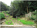
6
Gorse Hall Mansion Summer House (former site)
Site of the Leech Family's "Summer House" on the Gorse Hall Estate, Stalybridge. Despite the name, ladies would use huts called "summer houses" to hide in so that sunlight did not harm their complexions!
"Gorse Hall" is the local name for a former estate (and site of two stately homes of the same name) on the border between Stalybridge and Dukinfield, Greater Manchester.
The first Gorse Hall ("Old Gorse Hall") dates back to at least the 1600's, and was demolished during the 1960's.
The New Gorse Hall Mansion was built in 1835 by local mill owner John Leech (grandfather of Beatrix Potter).
After his wife's death, the Mansion was bought by a local builder for his son, George Harry Storrs, who was murdered in mysterious circumstances on November 1st, 1909.
The bricks used to construct the New Mansion were then used to re-front the Banks in Stalybridge town centre.
Image: © Tom Hindley
Taken: 3 Jan 2012
0.19 miles
7
Old Gorse Hall
Old Gorse Hall was the oldest structure on the Gorse Hall Estate, dating back to at least the 1600's. The building itself survived until the 1960's.
"Gorse Hall" is the local name for a former estate (and site of two stately homes of the same name) on the border between Stalybridge and Dukinfield, Greater Manchester.
The first Gorse Hall ("Old Gorse Hall") dates back to at least the 1600's, and was demolished during the 1960's.
The New Gorse Hall Mansion was built in 1835 by local mill owner John Leech (grandfather of Beatrix Potter).
After his wife's death, the Mansion was bought by a local builder for his son, George Harry Storrs, who was murdered in mysterious circumstances on November 1st, 1909.
The bricks used to construct the New Mansion were then used to re-front the Banks in Stalybridge town centre.
Image: © Tom Hindley
Taken: 3 Jan 2012
0.24 miles
8
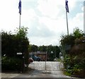
Mottram Road Allotments Society
Entrance to Mottram Road Allotments.
Image: © Gerald England
Taken: 28 Jun 2009
0.24 miles
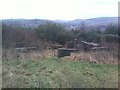
9

Approach to Gorse Hall Mansion
The view as walkers approach the site of the "New Gorse Hall Mansion", in Stalybridge.
"Gorse Hall" is the local name for a former estate (and site of two stately homes of the same name) on the border between Stalybridge and Dukinfield, Greater Manchester.
The first Gorse Hall ("Old Gorse Hall") dates back to at least the 1600's, and was demolished during the 1960's.
The New Gorse Hall Mansion was built in 1835 by local mill owner John Leech (grandfather of Beatrix Potter).
After his wife's death, the Mansion was bought by a local builder for his son, George Harry Storrs, who was murdered in mysterious circumstances on November 1st, 1909.
The bricks used to construct the New Mansion were then used to re-front the Banks in Stalybridge town centre.
Image: © Tom Hindley
Taken: 3 Jan 2012
0.24 miles