1
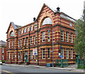
Stalybridge: Flats and police station
The nearer large building, now converted into flats, is the former headquarters of the SHMD tramways, also a supplier of electricity. Further along is the Police station.
Image: © Dr Neil Clifton
Taken: 10 Jul 2010
0.00 miles
2
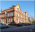
Stalybridge - former school on Waterloo Road
This was built in 1909 as Waterloo Road Girls' Secondary School, until it was replaced by Copley High School. The building has seen constant use since the schoolgirls moved out. For many years it housed Tameside's Teachers' Centre as well as council offices. More recently part of it has become Stalybridge Police Station.
The building has no connection with the Waterloo Road School of TV-series fame. The setting for this was Rochdale's Hill Top Primary School (see
Image).
See also: http://ashton-under-lyne.blogspot.co.uk/2009/02/stalybridge-saturday-waterloo-road.html and http://www.tameside.gov.uk/planning/ldf/evidence/caamp/stalybridge.pdf .
Image: © Dave Bevis
Taken: 19 Aug 2013
0.00 miles
3
Stalybridge - Waterloo Road School brickwork detail
Image: © Dave Bevis
Taken: 19 Aug 2013
0.00 miles
4
Thorn House
The Grade II listed https://historicengland.org.uk/listing/the-list/list-entry/1240077?section=official-list-entry Thorn House dates from 1903. It was the former Stalybridge, Hyde, Mossley & Dukinfield (SHMD) Tramways & Electricity Board headquarters building. SHMD was a public transport and electricity supply company formed by Act of Parliament in August 1901. It was a joint venture between the borough councils of Stalybridge, Hyde, Mossley and Dukinfield. The system was officially opened on 21 May 1904. In 1948, the SHMD electricity interests were nationalised, with the board's electricity distribution assets being incorporated into Norweb (North West Electricity Board). Thorn House was used for many years by Norweb as an area office and showroom before being sold and converted into flats.
Image: © Gerald England
Taken: 13 Feb 2023
0.00 miles
5
Stalybridge - former power company HQ
Thorn House on Waterloo Road is a Grade II listed building, built in 1903-4 by W.H. George. It was the former Stalybridge, Hyde, Mossley & Dukinfield (SHMD) Tramways & Electricity Board headquarters building. SHMD was a public transport and electricity supply company formed by Act of Parliament in August 1901. It was a joint venture between the borough councils of Stalybridge, Hyde, Mossley and Dukinfield. The system was officially opened on 21 May 1904. In 1948, the SHMD electricity interests were nationalised, with the board's electricity distribution assets being incorporated into Norweb (North West Electricity Board). Thorn House was used for many years by Norweb as an area office and showroom before being sold and converted into flats.
For more information, please see http://www.tameside.gov.uk/planning/ldf/evidence/caamp/stalybridge.pdf and
http://en.wikipedia.org/wiki/SHMD .
Image: © Dave Bevis
Taken: 19 Aug 2013
0.01 miles
6
Stalybridge: Waterloo Road
Image: © Dr Neil Clifton
Taken: 24 Oct 2013
0.01 miles
7
St Andrew's House
Now used mainly as a medical centre it was built in 1909 as Waterloo Road Girls' Secondary School. In recent years it has housed Tameside's Teachers' Centre as well as council offices and part of it become Stalybridge Police Station.
Image: © Gerald England
Taken: 13 Feb 2023
0.01 miles
8
Stalybridge
The police station in Stalybridge.
Image: © Peter McDermott
Taken: 29 Aug 2015
0.02 miles
9
St Andrew's House
Now used mainly as a medical centre it was built in 1909 as Waterloo Road Girls' Secondary School. In recent years it has housed Tameside's Teachers' Centre as well as council offices and part of it became Stalybridge Police Station.
Image: © Gerald England
Taken: 13 Feb 2023
0.02 miles
10
##4 & 6 Waterloo Road
A pair of semi-detached houses in the centre of Stalybridge. On the left is Stalybridge Old Fire Station
Image built in 1904 and now the home of Prestige Kitchens. On the wall is the town's coat of arms
Image
Image: © Gerald England
Taken: 13 Feb 2023
0.03 miles


