IMAGES TAKEN NEAR TO
Market Street, STALYBRIDGE, SK15 2AB
Introduction
This page details the photographs taken nearby to Market Street, SK15 2AB by members of the Geograph project.
The Geograph project started in 2005 with the aim of publishing, organising and preserving representative images for every square kilometre of Great Britain, Ireland and the Isle of Man.

There are currently over 7.5m images from over14,400 individuals and you can help contribute to the project by visiting https://www.geograph.org.uk
Image Map
Images are licensed for reuse under creativecommons.org/licenses/by-sa/2.0
Notes
- Clicking on the map will re-center to the selected point.
- The higher the marker number, the further away the image location is from the centre of the postcode.
Image Listing (429 Images Found)
Images are licensed for reuse under creativecommons.org/licenses/by-sa/2.0
Image
Details
Distance
1
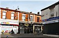
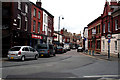
Market Street/Melbourne Street, Stalybridge
Opposite the end of Melbourne Street, the Reem coffee lounge and wine bar (in a building dated 1852) is flanked by Gino's Hair Design on one side and the GoLocalExtra convenience store. At the end of Melbourne Street is the Sunspot tanning studio. This used to be Boots the chemist.
Image: © Gerald England
Taken: 4 Mar 2013
0.01 miles
2
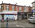
Shops on Market Street
Compare with Image taken in 2013. Gino's Hair Design is still going but the Reem coffee lounge and wine bar is now Twinkle (having been Handbag's bar for some time in between) and the GoLocalExtra convenience store is now an OV store.
Image: © Gerald England
Taken: 30 May 2017
0.01 miles
3
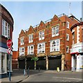
Zurri Indian Cuisine
The Zurri Indian restaurant at 80-84 Market Street.
Image: © Gerald England
Taken: 4 Mar 2013
0.01 miles
4
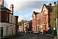
Stalybridge: Market Street
Looking at Market Street, Stalybridge through what is left of the Grade II listed https://historicengland.org.uk/listing/the-list/list-entry/1067987 Town Hall. Image
Image: © Gerald England
Taken: 31 Oct 2008
0.01 miles
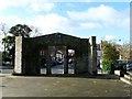
5
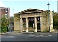
Stalybridge Town Hall Portico
All that is left of the Grade II listed https://historicengland.org.uk/listing/the-list/list-entry/1067987 Stalybridge Town Hall, long since demolished.
Compare with 2004 view Image
Image: © Gerald England
Taken: 31 Oct 2008
0.02 miles
6
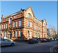
St Andrew's House
Now used mainly as a medical centre it was built in 1909 as Waterloo Road Girls' Secondary School. In recent years it has housed Tameside's Teachers' Centre as well as council offices and part of it become Stalybridge Police Station.
Image: © Gerald England
Taken: 13 Feb 2023
0.02 miles
7
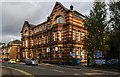
Stalybridge
The police station in Stalybridge.
Image: © Peter McDermott
Taken: 29 Aug 2015
0.02 miles
10
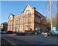
St Andrew's House
Now used mainly as a medical centre it was built in 1909 as Waterloo Road Girls' Secondary School. In recent years it has housed Tameside's Teachers' Centre as well as council offices and part of it became Stalybridge Police Station.
Image: © Gerald England
Taken: 13 Feb 2023
0.03 miles