1
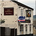
Signage of The Norman
Signage on The Norman on Oxford Road
Image
The pub was "for lease" when this photograph was taken but has since been demolished and the land used for housing.
Image: © Gerald England
Taken: 31 Jul 2008
0.03 miles
2
St John's Church, Dukinfield
St John's Church stands in an elevated position at the top of a small hill above Oxford Road in Dukinfield. It is an example of a Commissioners' church (http://en.wikipedia.org/wiki/Commissioners%27_church ) designed by the Lancaster architect Edmund Sharpe, and built in 1838–40. It is a Grade II listed building (https://historicengland.org.uk/listing/the-list/list-entry/1068017 National Heritage List for England)
Image: © David Dixon
Taken: 9 Nov 2012
0.05 miles
3
Dukinfield St John's
St John's Church stands in an elevated position at the top of a small hill above Oxford Road in Dukinfield. It is an example of a Commissioners' church (http://en.wikipedia.org/wiki/Commissioners%27_church ) designed by the Lancaster architect Edmund Sharpe, and built in 1838–40. It is a Grade II listed building (https://historicengland.org.uk/listing/the-list/list-entry/1068017 National Heritage List for England)
Image: © David Dixon
Taken: 9 Nov 2012
0.05 miles
4
Oxford Road
Just past the "Norman" public house
Image, Oxford Road, Dukinfield changes to High Street, Stalybridge.
The pub was "for lease" when this photograph was taken but has since been demolished and the land used for housing.
Image: © Gerald England
Taken: 31 Jul 2008
0.05 miles
5
The Church of St John the Evangelist, Dukinfield
St John's Church stands in an elevated position at the top of a small hill above Oxford Road in Dukinfield. It is an example of a Commissioners' church (http://en.wikipedia.org/wiki/Commissioners%27_church ) designed by the Lancaster architect Edmund Sharpe, and built in 1838–40. It is a Grade II listed building (https://historicengland.org.uk/listing/the-list/list-entry/1068017 National Heritage List for England)
Image: © David Dixon
Taken: 9 Nov 2012
0.05 miles
6
Dukinfield, The Church of St John the Evangelist
St John's Church stands in an elevated position at the top of a small hill above Oxford Road in Dukinfield. It is an example of a Commissioners' church (http://en.wikipedia.org/wiki/Commissioners%27_church ) designed by the Lancaster architect Edmund Sharpe, and built in 1838–40. It is a Grade II listed building (https://historicengland.org.uk/listing/the-list/list-entry/1068017 National Heritage List for England).
This view is from the west, looking along Vicarage Drive.
Image: © David Dixon
Taken: 9 Nov 2012
0.05 miles
7
St John's, Dukinfield
Viewed from Stalybridge Station using a zoom lens.
Image: © Gerald England
Taken: 7 Feb 2011
0.06 miles
8
St John's Dukinfield
Viewed from Vicarage Drive. The old school is now mews property.
Image: © Gerald England
Taken: 31 Jul 2008
0.06 miles
9
Dukinfield
Looking along Oxford Road towards Stalybridge. The hill in the centre distance is Harridge Pike in SJ9999.
Image: © Keith Williamson
Taken: 15 Sep 2007
0.10 miles
10
Former tramway power station
Built 1903 as tram depot and power station. Logo - SHMD 1903 (Stalybridge, Hyde, Mossley & Dukinfield Joint Transport). The garage was on the east side (closest to photographer) and appears to have been demolished quite recently.
Image: © Chris Allen
Taken: 13 Feb 2010
0.10 miles


