IMAGES TAKEN NEAR TO
Holly Grove, STALYBRIDGE, SK15 1UW
Introduction
This page details the photographs taken nearby to Holly Grove, SK15 1UW by members of the Geograph project.
The Geograph project started in 2005 with the aim of publishing, organising and preserving representative images for every square kilometre of Great Britain, Ireland and the Isle of Man.

There are currently over 7.5m images from over14,400 individuals and you can help contribute to the project by visiting https://www.geograph.org.uk
Image Map
Images are licensed for reuse under creativecommons.org/licenses/by-sa/2.0
Notes
- Clicking on the map will re-center to the selected point.
- The higher the marker number, the further away the image location is from the centre of the postcode.
Image Listing (58 Images Found)
Images are licensed for reuse under creativecommons.org/licenses/by-sa/2.0
Image
Details
Distance
1
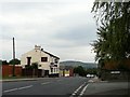
Oxford Road
Just past the "Norman" public house Image, Oxford Road, Dukinfield changes to High Street, Stalybridge.
The pub was "for lease" when this photograph was taken but has since been demolished and the land used for housing.
Image: © Gerald England
Taken: 31 Jul 2008
0.04 miles
2
St John's, Dukinfield
Viewed from Stalybridge Station using a zoom lens.
Image: © Gerald England
Taken: 7 Feb 2011
0.05 miles
3
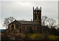
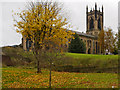
Dukinfield St John's
St John's Church stands in an elevated position at the top of a small hill above Oxford Road in Dukinfield. It is an example of a Commissioners' church (http://en.wikipedia.org/wiki/Commissioners%27_church ) designed by the Lancaster architect Edmund Sharpe, and built in 1838–40. It is a Grade II listed building (https://historicengland.org.uk/listing/the-list/list-entry/1068017 National Heritage List for England)
Image: © David Dixon
Taken: 9 Nov 2012
0.05 miles
4
St John's Dukinfield
Viewed from Vicarage Drive. The old school is now mews property.
Image: © Gerald England
Taken: 31 Jul 2008
0.06 miles
5
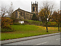
The Church of St John the Evangelist, Dukinfield
St John's Church stands in an elevated position at the top of a small hill above Oxford Road in Dukinfield. It is an example of a Commissioners' church (http://en.wikipedia.org/wiki/Commissioners%27_church ) designed by the Lancaster architect Edmund Sharpe, and built in 1838–40. It is a Grade II listed building (https://historicengland.org.uk/listing/the-list/list-entry/1068017 National Heritage List for England)
Image: © David Dixon
Taken: 9 Nov 2012
0.06 miles
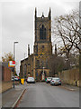
6
St John's Church, Dukinfield
St John's Church stands in an elevated position at the top of a small hill above Oxford Road in Dukinfield. It is an example of a Commissioners' church (http://en.wikipedia.org/wiki/Commissioners%27_church ) designed by the Lancaster architect Edmund Sharpe, and built in 1838–40. It is a Grade II listed building (https://historicengland.org.uk/listing/the-list/list-entry/1068017 National Heritage List for England)
Image: © David Dixon
Taken: 9 Nov 2012
0.07 miles
7
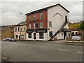
The Bridgefield
Formerly "The Bridgefield Hotel", a traditional public house, this is now "The Bridgefield Curry Lounge".
Image: © David Dixon
Taken: 9 Nov 2012
0.07 miles
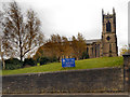
8
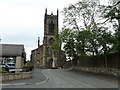
Dukinfield, The Church of St John the Evangelist
St John's Church stands in an elevated position at the top of a small hill above Oxford Road in Dukinfield. It is an example of a Commissioners' church (http://en.wikipedia.org/wiki/Commissioners%27_church ) designed by the Lancaster architect Edmund Sharpe, and built in 1838–40. It is a Grade II listed building (https://historicengland.org.uk/listing/the-list/list-entry/1068017 National Heritage List for England).
This view is from the west, looking along Vicarage Drive.
Image: © David Dixon
Taken: 9 Nov 2012
0.07 miles
9
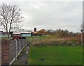
St John's Primary School
From Cheetham Hill Road, looking across the playing fields of St John's Primary School towards St John's Church Image
Image: © Gerald England
Taken: 22 Nov 2009
0.10 miles
10
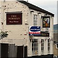
Signage of The Norman
Signage on The Norman on Oxford Road Image
The pub was "for lease" when this photograph was taken but has since been demolished and the land used for housing.
Image: © Gerald England
Taken: 31 Jul 2008
0.11 miles