IMAGES TAKEN NEAR TO
Bohemia Cottages, STALYBRIDGE, SK15 1JY
Introduction
This page details the photographs taken nearby to Bohemia Cottages, SK15 1JY by members of the Geograph project.
The Geograph project started in 2005 with the aim of publishing, organising and preserving representative images for every square kilometre of Great Britain, Ireland and the Isle of Man.

There are currently over 7.5m images from over14,400 individuals and you can help contribute to the project by visiting https://www.geograph.org.uk
Image Map
Images are licensed for reuse under creativecommons.org/licenses/by-sa/2.0
Notes
- Clicking on the map will re-center to the selected point.
- The higher the marker number, the further away the image location is from the centre of the postcode.
Image Listing (321 Images Found)
Images are licensed for reuse under creativecommons.org/licenses/by-sa/2.0
Image
Details
Distance
1

Empty shop in Stalybridge
Plenty of empty shops around here.
Image: © Paul Foster
Taken: 18 Jan 2022
0.03 miles
2
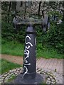
Five ton hoist post
This is the remains of a hoist that unloaded the barges that brought goods to Stalybridge around 1850/1950.
Image: © Michael John Lillie
Taken: 25 Sep 2006
0.04 miles
4
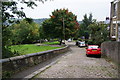
Cocker Hill, Stalybridge
The site of Old St George's Church is on the left.
Image: © Bill Boaden
Taken: 28 Sep 2010
0.06 miles
5
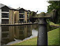
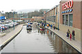
Waterside apartments, Stalybridge
Built close to lock 7W on the Huddersfield narrow Canal near to where the canal passes beneath Portland Place.
Image: © michael ely
Taken: 8 Jul 2010
0.06 miles
6
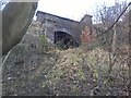
Cocker Hill Railway Tunnel, eastern exit
The Micklehurst Line was a former railway line which linked Stalybridge Railway Station with Diggle, via a route adjacent to the River Tame and containing four small railway stations.
The route immediately east of Stalybridge Railway Station ran under Cocker Hill, and this is the eastern opening of that tunnel, which can still be accessed by some of the more nimble and determined locals!
Image: © Tom Hindley
Taken: 3 Jan 2012
0.06 miles
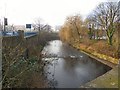
7
Huddersfield Canal in Stalybridge
The Huddersfield Narrow Canal passing through Stalybridge. This section had been in-filled but was restored and re-opened in 2001.
Image: © Martin Clark
Taken: Unknown
0.06 miles
8
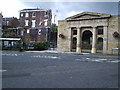
Stalybridge town hall monument
AS you can see in the photo there are two blue plaques on the town hall commemorating local events.
One plaque commemorates the 'first general strike' which originated in this area. It began as a movement of resistance to the imposition of wage cuts in the mills and was also known as the 'Plug Riots'. It spread to involve nearly half a million workers throughout Britain and represented the biggest single exercise of working class strength in nineteenth century Britain.
Image: © david nike
Taken: 16 Aug 2004
0.06 miles
9
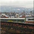
Stalybridge from the station
On the right is the tower of Holy Trinity Image To the left is the former Victoria Market Image closed since 2002. Beyond are the snow covered slopes of the Pennines.
Image: © Gerald England
Taken: 16 Dec 2017
0.06 miles
10
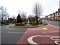
Top of Market Street
The junction of Mottram Road (A6018) and Market Street (B6176). Behind the junction is a memorial to local philanthropist Robert Platt Image
Image: © Gerald England
Taken: 11 Jan 2018
0.07 miles