IMAGES TAKEN NEAR TO
Springs Lane, STALYBRIDGE, SK15 1JD
Introduction
This page details the photographs taken nearby to Springs Lane, SK15 1JD by members of the Geograph project.
The Geograph project started in 2005 with the aim of publishing, organising and preserving representative images for every square kilometre of Great Britain, Ireland and the Isle of Man.

There are currently over 7.5m images from over14,400 individuals and you can help contribute to the project by visiting https://www.geograph.org.uk
Image Map
Images are licensed for reuse under creativecommons.org/licenses/by-sa/2.0
Notes
- Clicking on the map will re-center to the selected point.
- The higher the marker number, the further away the image location is from the centre of the postcode.
Image Listing (68 Images Found)
Images are licensed for reuse under creativecommons.org/licenses/by-sa/2.0
Image
Details
Distance
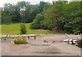
1
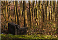
Stamford Park
Sofa in Stamford Park.
Image: © Peter McDermott
Taken: 2 Jan 2015
0.09 miles
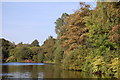
2
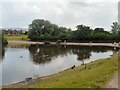
Stamford Park Fishing Lake
Behind the trees is the Boating Lake. The houses in the background are part of the Ridge Hill estate.
Image: © Gerald England
Taken: 28 Jun 2009
0.10 miles
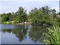
3
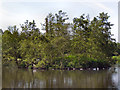
Stamford Park Upper Lake
The former mill reservoir known as Chadwick Dams was incorporated into Stamford Park in 1891.
The reservoir was divided in two by an embankment, with the southern section becoming the present boating lake. This, the northern section, is used mostly for fishing.
Image: © David Dixon
Taken: 14 Jun 2011
0.11 miles
4
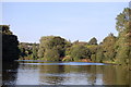
Ashton under Lyne : Stamford Park Boating Lake
Image: © Ken Bagnall
Taken: 12 Sep 2009
0.12 miles
5
Ashton under Lyne : Stamford Park Boating Lake
Image: © Ken Bagnall
Taken: 12 Sep 2009
0.12 miles
6
Bench with Ducks
In Upper Stamford Park, a bench near the fishing lake is surrounded by ducks.
Image: © Gerald England
Taken: 28 Jun 2009
0.12 miles
7
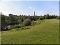
Stamford Park Fishing Lake
In the background is the chimney belonging to Tameside Hospital Image
Image: © Gerald England
Taken: 28 Jun 2009
0.12 miles
8
Stamford Park Upper Lake
The former mill reservoir known as Chadwick Dams was incorporated into Stamford Park in 1891.
The reservoir was divided in two by an embankment, with the southern section becoming the present boating lake. This, the northern section, is used mostly for fishing by the Ridge Hill Angling Club.
Image: © David Dixon
Taken: 14 Jun 2011
0.12 miles
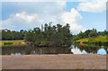
10
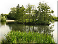
The Island, Stamford Park Upper Lake
The former mill reservoir known as Chadwick Dams was incorporated into Stamford Park in 1891.
The reservoir was divided in two by an embankment, with the southern section becoming the present boating lake. This, the northern section, is used mostly for fishing.
Image: © David Dixon
Taken: 14 Jun 2011
0.13 miles