IMAGES TAKEN NEAR TO
Keswick Close, STALYBRIDGE, SK15 1HR
Introduction
This page details the photographs taken nearby to Keswick Close, SK15 1HR by members of the Geograph project.
The Geograph project started in 2005 with the aim of publishing, organising and preserving representative images for every square kilometre of Great Britain, Ireland and the Isle of Man.

There are currently over 7.5m images from over14,400 individuals and you can help contribute to the project by visiting https://www.geograph.org.uk
Image Map
Images are licensed for reuse under creativecommons.org/licenses/by-sa/2.0
Notes
- Clicking on the map will re-center to the selected point.
- The higher the marker number, the further away the image location is from the centre of the postcode.
Image Listing (18 Images Found)
Images are licensed for reuse under creativecommons.org/licenses/by-sa/2.0
Image
Details
Distance
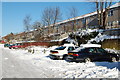
1
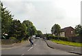
Windermere Road
On the Ridge Hill Estate.
Image: © Gerald England
Taken: 27 Jun 2009
0.04 miles
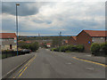
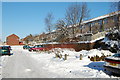
3
Ullswater Terrace
On the Ridge Hill Estate.
Image: © Gerald England
Taken: 27 Jun 2009
0.08 miles
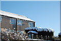

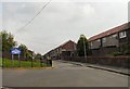
10
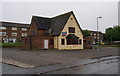
The Peacock
Unfortunately another closed pub, on Ambleside in Ridge Hill.
Image: © Bill Boaden
Taken: 26 May 2010
0.15 miles