IMAGES TAKEN NEAR TO
Ullswater Road, STOCKPORT, SK1 4NH
Introduction
This page details the photographs taken nearby to Ullswater Road, SK1 4NH by members of the Geograph project.
The Geograph project started in 2005 with the aim of publishing, organising and preserving representative images for every square kilometre of Great Britain, Ireland and the Isle of Man.

There are currently over 7.5m images from over14,400 individuals and you can help contribute to the project by visiting https://www.geograph.org.uk
Image Map
Images are licensed for reuse under creativecommons.org/licenses/by-sa/2.0
Notes
- Clicking on the map will re-center to the selected point.
- The higher the marker number, the further away the image location is from the centre of the postcode.
Image Listing (8 Images Found)
Images are licensed for reuse under creativecommons.org/licenses/by-sa/2.0
Image
Details
Distance
1
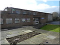
Stockport Lads Club
Henmpshaw Lane, having moved to these premises from Image
Image: © Peter Barr
Taken: 15 Feb 2013
0.14 miles
2
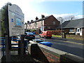
Doug and Di's Off-Licence
Local shop in Stockport, on Maitland Street.
Image: © Peter Barr
Taken: 15 Feb 2013
0.17 miles
3
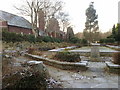
Memorial garden next to the cemetery chapel
A quiet area in the centre of Stockport Cemetery.
Image: © Bill Boaden
Taken: 29 Nov 2010
0.22 miles
4
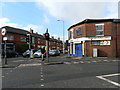
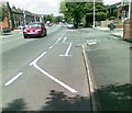
Traffic light at junction, and business premises
Bank's Lane and Hempshaw Lane. Power tools shop.
Image: © Peter Barr
Taken: 15 Feb 2013
0.23 miles
6
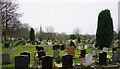
Stockport Cemetery
Seen on a grey day, with St George's church showing behind.
Image: © Bill Boaden
Taken: 12 Mar 2015
0.24 miles
7
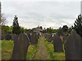
Stockport Cemetery
With the crematorium in the background.
Image: © Gerald England
Taken: 30 Apr 2009
0.25 miles
8
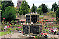
One of the cremation Memorials at Stockport Cemetery
St. George's Church, can be seen through the trees.
Image: © Geoff Royle
Taken: 27 Aug 2007
0.25 miles