IMAGES TAKEN NEAR TO
Church Brow, HYDE, SK14 6JJ

Introduction

This page details the photographs taken nearby to Church Brow, SK14 6JJ by members of the Geograph project.

The Geograph project started in 2005 with the aim of publishing, organising and preserving representative images for every square kilometre of Great Britain, Ireland and the Isle of Man.

There are currently over 7.5m images from over14,400 individuals and you can help contribute to the project by visiting https://www.geograph.org.uk

Image Map


Images are licensed for reuse under creativecommons.org/licenses/by-sa/2.0
Notes
  • Clicking on the map will re-center to the selected point.
  • The higher the marker number, the further away the image location is from the centre of the postcode.

Image Listing (174 Images Found)

Images are licensed for reuse under creativecommons.org/licenses/by-sa/2.0
  • ...
Image
Details
Distance
1
Path from Mottram Church
Cobbled path leading down from St Michael and All Angels towards the Market Place.
Image: © Gerald England Taken: 8 Aug 2009
0.01 miles
2
Secret door in Mottram -in-Longdendale
By the cobbled track that leads up to the village church. The carved plaque above the door bears the date "1769".
Image: © Neil Theasby Taken: 8 Jun 2021
0.01 miles
3
Church Brow Footpath
Footpath leading down from St Michael & All Angels Church at Mottram in Longdendale.
Image: © Gerald England Taken: 16 Jan 2003
0.01 miles
4
Mottram Churchyard
The view from the burial ground at St Michael and All Angels, Mottram in Longdendale.
Image: © Gerald England Taken: 8 Aug 2009
0.01 miles
5
Mottram in Longdendale
The view from Roe Cross.
Image: © Gerald England Taken: 15 Apr 2008
0.02 miles
6
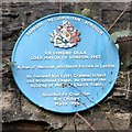
Blue plaque for Edmund Shaa
The blue plaque on Church Brow reads: TAMESIDE METROPOLITAN BOROUGH SIR EDMUND SHAA LORD MAYOR OF LONDON, 1482 A man of Mottram who found fortune in London He founded Stockport Grammar School and Woodhead Chapel. He financed the building of Mottram Church Tower. Unveiled by Councillor Roy Oldham March 1994
Image: © Gerald England Taken: 16 Jan 2003
0.02 miles
7
Manners makyth Man
Engraving in the stone above the door of School House Image
Image: © Gerald England Taken: 16 Jan 2003
0.02 miles
8
Mottram Parish Church from Stalybridge Road
The church towers over the whole village. The notorious bottleneck crossroads is behind the parked truck.
Image: © Bill Boaden Taken: 14 Dec 2009
0.03 miles
9
Mottram scene
The parish church stands behind. In the foreground is one of the multiple junctions off Roe Cross Road, this one with Old Road and Old Hall Lane.
Image: © Bill Boaden Taken: 14 Dec 2009
0.03 miles
10
St. Michael & All Angels (Mottram Church)
The Church Tower,Situated on War Hill the present church dates from around the 1490's.In 1855 the church underwent a restoration.
Image: © Stephen Burton Taken: 9 May 2010
0.03 miles
  • ...