IMAGES TAKEN NEAR TO
Hinton Grove, HYDE, SK14 5ST
Introduction
This page details the photographs taken nearby to Hinton Grove, SK14 5ST by members of the Geograph project.
The Geograph project started in 2005 with the aim of publishing, organising and preserving representative images for every square kilometre of Great Britain, Ireland and the Isle of Man.

There are currently over 7.5m images from over14,400 individuals and you can help contribute to the project by visiting https://www.geograph.org.uk
Image Map
Images are licensed for reuse under creativecommons.org/licenses/by-sa/2.0
Notes
- Clicking on the map will re-center to the selected point.
- The higher the marker number, the further away the image location is from the centre of the postcode.
Image Listing (115 Images Found)
Images are licensed for reuse under creativecommons.org/licenses/by-sa/2.0
Image
Details
Distance
1
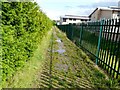
Path behind Alder School
Although it is bright afternoon sunshine as the shadows across the path indicate, after days of heavy rain the footpath running along the back of Alder School is full of very muddy puddles.
Compare with view in January 2009: Image
Image: © Gerald England
Taken: 6 Sep 2008
0.01 miles
2

Footpath to Hinton Grove
Footpath from Alder School to Hinton Grove.
Image: © Gerald England
Taken: 31 Jan 2009
0.01 miles
3
Hinton Grove
New houses under construction.
Image: © Gerald England
Taken: 28 Aug 1993
0.02 miles
4
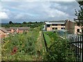
Behind Alder Community School
A footpath from Grange Road South leads behind Alder Community School past Hinton Avenue towards Green Lane.
Image: © Gerald England
Taken: 26 Aug 2006
0.02 miles
5
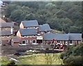
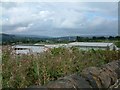
Looking over Hinton Grove
Alder School grounds are on the left.
Image: © Gerald England
Taken: 31 Jan 2009
0.03 miles
6
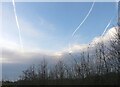
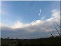
Contrails above Alder School
The school lies under the flightpath of planes heading for Manchester Airport. The contrails are probably from planes flying out at higher altitudes or possibly circling before a final approach.
Image: © Gerald England
Taken: 31 Jan 2009
0.04 miles
7
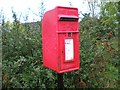
Little Postbox
Postbox on Grange Road South.
Image: © Gerald England
Taken: 4 Nov 2006
0.04 miles
8
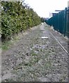
Footpath behind Alder School
Image: © Gerald England
Taken: 31 Jan 2009
0.04 miles
9
Site of Alder Community School
The site of Alder Community School before construction began.
Image: © Gerald England
Taken: 1 Mar 2002
0.04 miles
10
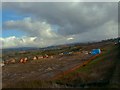
Over School Roofs
From Mottram Old Road looking over the roofs of Alder Community School towards the Longdendale Valley in the far distance.
Compare with the view before the school was built. Image
Image: © Gerald England
Taken: 26 Aug 2006
0.05 miles