IMAGES TAKEN NEAR TO
King Edward Road, HYDE, SK14 5JN
Introduction
This page details the photographs taken nearby to King Edward Road, SK14 5JN by members of the Geograph project.
The Geograph project started in 2005 with the aim of publishing, organising and preserving representative images for every square kilometre of Great Britain, Ireland and the Isle of Man.

There are currently over 7.5m images from over14,400 individuals and you can help contribute to the project by visiting https://www.geograph.org.uk
Image Map
Images are licensed for reuse under creativecommons.org/licenses/by-sa/2.0
Notes
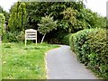
- Clicking on the map will re-center to the selected point.
- The higher the marker number, the further away the image location is from the centre of the postcode.
Image Listing (800 Images Found)
Images are licensed for reuse under creativecommons.org/licenses/by-sa/2.0
Image
Details
Distance
1
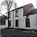
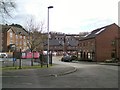
Gee Cross Sports Social Club
The Social Club on King Edward Avenue is boarded up and appears to have an uncertain future. Read the sign Image
Update October 2009: The sign has since been removed.
Update June 2014: Now a beauty parlour Image
Image: © Gerald England
Taken: 17 Mar 2009
0.05 miles
2
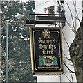
Samuel Smith's Beer
Sign outside Gee Cross Social Club on King Edward Avenue Image
Update October 2009: The sign has since been removed.
Image: © Gerald England
Taken: 17 Mar 2009
0.05 miles
3
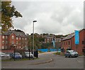
King Edwards Court
A development of new houses off King Edward Avenue in what was once a quarry. Behind the quarry-retaining wall is "The Werneth" on Stockport Road adjacent to Treacle Brow. See the view in opposite direction from Treacle Brow Image
Image: © Gerald England
Taken: 10 Oct 2009
0.05 miles
4
King Edward Avenue
A view from the top of Treacle Brow Image of the building work on King Edward Avenue.
Compare with the view in March 2009 Image
Image: © Gerald England
Taken: 6 May 2008
0.06 miles
5
Dowson Trail
Entrance from Armitage Close on to the Dowson Trail. A permissive path around Dowson Primary School leading to Gower Hey Woods and the Trans Pennine Trail.
Image: © Gerald England
Taken: 14 Jun 2015
0.06 miles
6
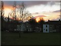
Sunset over King Edward Avenue
Viewed from Diamond Row Open Space. The spire of Hyde Chapel is visible on the left.
Image: © Gerald England
Taken: 27 Dec 2008
0.06 miles
7
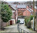
King Edward Court
Looking down Treacle Brow and over Stockport Road to some of the houses in King Edward Court, a new development on King Edward Avenue. Compare with the view of construction work in May 2008 Image
Image: © Gerald England
Taken: 12 Mar 2009
0.06 miles
8
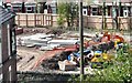
King Edwards Court
Now that the retaining wall on Stockport Road has been strengthened work is about to be begin on the building of more houses on this former quarry site.
Image: © Gerald England
Taken: 15 Apr 2017
0.06 miles
9
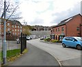
King Edwards Court
New houses are nearing completion on land off King Edward Avenue that was formerly a quarry. At one time it was the site of Whittaker's Whim, a 5 storey building built against the wall with 3 storeys below Stockport Road, and the top two storeys fronting onto Stockport Road. It was replaced by the original 2-storey stone-built factory used by G B Moores for the dressing of chamois leather and was known as "Glen Chamois". More information can be found on Old Hyde: http://oldhyde.blogspot.co.uk/2009/10/whittikers-whim.html New houses were built along the entrance to the land in 2009 Image In 2017 the retaining wall backing onto Stockport Road was strengthened Image and construction of more house on the land then commenced.
Image: © Gerald England
Taken: 25 Jan 2018
0.06 miles
10
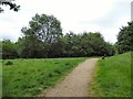
Field near Clough Gate
In Gower Hey Woods.
Image: © Gerald England
Taken: 14 Jun 2015
0.06 miles