IMAGES TAKEN NEAR TO
Hilda Road, HYDE, SK14 5EY
Introduction
This page details the photographs taken nearby to Hilda Road, SK14 5EY by members of the Geograph project.
The Geograph project started in 2005 with the aim of publishing, organising and preserving representative images for every square kilometre of Great Britain, Ireland and the Isle of Man.

There are currently over 7.5m images from over14,400 individuals and you can help contribute to the project by visiting https://www.geograph.org.uk
Image Map
Images are licensed for reuse under creativecommons.org/licenses/by-sa/2.0
Notes
- Clicking on the map will re-center to the selected point.
- The higher the marker number, the further away the image location is from the centre of the postcode.
Image Listing (227 Images Found)
Images are licensed for reuse under creativecommons.org/licenses/by-sa/2.0
Image
Details
Distance
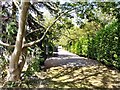
1
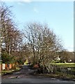
Hilda Road
A lane off Stockport Road, Gee Cross.
Image: © Gerald England
Taken: 24 Jan 2009
0.01 miles
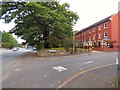
2
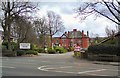
Bowlacre Home
Care home on Stockport Road.
Image: © Gerald England
Taken: 26 Mar 2010
0.02 miles
3
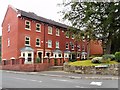
The Gerrards
In the 17th century, opposite the end of Apethorn Lane was a small group of cottages known as Gerrards Fold. The Ashton family farmed there before they embarked on the cotton trade in the district. Towards the end of the 19th century the old fold was converted into a large Elizabethan style house known as "The Gerrards".
James Bradley lived there around 1905, Gladstone stayed there too as did a ghost. The now disgraced Stuart Hall once wanted to buy the property but the then owner refused him.
At the turn of the 21st century the house was demolished and replaced by three-storey modern town houses.
For an old photograph see http://hydonian.blogspot.co.uk/2011/09/gerrards-gee-cross.html
Image: © Gerald England
Taken: 2 Jul 2014
0.04 miles
4
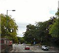
Stockport Road
Viewed from the top deck of a bus approaching Dowson Road.
Image: © Gerald England
Taken: 19 Jul 2010
0.04 miles
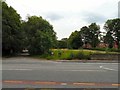
5
Rosemary Drive
A leafy cul-de-sac off Stockport Road.
Image: © Gerald England
Taken: 11 Jul 2010
0.04 miles
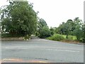
6
Hilda Road
Off Stockport Road. Bowlacre care home is on the right.
Image: © Gerald England
Taken: 2 Jul 2014
0.05 miles
8
The Gerrards
In the 17th century, opposite the end of Apethorn Lane was a small group of cottages known as Gerrards Fold. The Ashton family farmed there before they embarked on the cotton trade in the district. Towards the end of the 19th century the old fold was converted into a large Elizabethan style house known as "The Gerrards".
James Bradley lived there around 1905, Gladstone stayed there too as did a ghost. The now disgraced Stuart Hall once wanted to buy the property but then owner refused him.
At the turn of the 21st century the house was demolished and replaced by 3-storey modern town houses.
For an old photograph see http://hydonian.blogspot.co.uk/2011/09/gerrards-gee-cross.html
Image: © Gerald England
Taken: 21 Sep 2016
0.05 miles
9
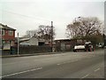
Tractor outside Pear Tree Farm
A tractor and a trailer outside Pear Tree Farm on Stockport Road.
Image: © Gerald England
Taken: 19 Jan 2017
0.05 miles
10
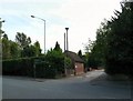
Rosemary Drive
Off Stockport Road. I am given to understand that on top of the pole above the electricity sub-station is an air-raid siren which was rescued from a building that used to be at the top of Apethorn Lane.
Image: © Gerald England
Taken: 11 Jul 2010
0.05 miles