IMAGES TAKEN NEAR TO
Laurel Bank, HYDE, SK14 5DX
Introduction
This page details the photographs taken nearby to Laurel Bank, SK14 5DX by members of the Geograph project.
The Geograph project started in 2005 with the aim of publishing, organising and preserving representative images for every square kilometre of Great Britain, Ireland and the Isle of Man.

There are currently over 7.5m images from over14,400 individuals and you can help contribute to the project by visiting https://www.geograph.org.uk
Image Map
Images are licensed for reuse under creativecommons.org/licenses/by-sa/2.0
Notes
- Clicking on the map will re-center to the selected point.
- The higher the marker number, the further away the image location is from the centre of the postcode.
Image Listing (128 Images Found)
Images are licensed for reuse under creativecommons.org/licenses/by-sa/2.0
Image
Details
Distance
1
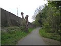
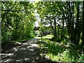
Trans Pennine Trail at Apethorn Lane
On reaching Bridge #119 on the former railway line from Godley Junction to Apethorn, the Trans Pennine Trail and National Cycle Network Route #62 needs to leave the trackbed as the next section joined the main line from Hyde to Woodley a few hundred yards beyond this point and so is abandoned Access is prevented by heaving railings across the front of the bridge. The trail route goes down Apethorn Lane towards the Peak Forest Canal.
Image: © Gerald England
Taken: 26 Apr 2020
0.01 miles
2
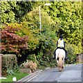
Horesrider on Apethorn Lane
On the left a path leads to the Trans Pennine Trail towards Godley.
Image: © Gerald England
Taken: 30 Sep 2016
0.01 miles
3
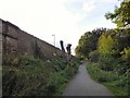
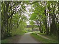
Pollarded trees by Apethorn Lane bridge
On reaching Bridge #119 Image on the former railway line from Godley Junction to Apethorn, the Trans Pennine Trail and National Cycle Network Route #62 needs to leave the trackbed as the next section joined the main line from Hyde to Woodley a few hundred yards beyond this point and so is abandoned Image Access is prevented by heaving railings across the front of the bridge. The route is down Apethorn Lane towards the Peak Forest Canal.
Image: © Gerald England
Taken: 30 Sep 2016
0.01 miles
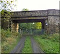
6
Apethorn Lane Bridge
The Apethorn Lane Bridge (now numbered 119) over the former Godley to Apethorn railway line. This section is part of the TransPennine Trail. Beyond the bridge, the line shortly joined the still open Hyde to Woodley railway. Access beyond the bridge is therefore barred and users of the trail are diverted towards the Peak Forest Canal. In the foreground is a Sustran's Milepost Image
Image: © Gerald England
Taken: 1 Jun 2014
0.02 miles
7
Bridge #119
Bridge #119 takes Apethorn Lane over the former railway line from Godley Junction to Apethorn. The "Cheshire Lines Committee (CLC)" route opened in 1866. Following the electrification of the Woodhead line in 1954 and until 1981 when the through route to Sheffield closed, the main traffic on the line consisted of trains from the Yorkshire coalfield to the Fiddlers Ferry power station. Most of former trackbed is now utilised by the Trans Pennine Trail and National Cycle Network Route #62 but this section joined the main line from Hyde to Woodley a few hundred yards beyond this point and so is abandoned with access prevented by heavy railings across the front of the bridge. The trail turns right towards the Peak Forest Canal. In the foreground is a Sustran's Milepost.
Image: © Gerald England
Taken: 26 Apr 2020
0.02 miles
8

Abandoned railway line
The view through the railings under Apethorn Lane Bridge of the end of the former Godley to Apethorn railway which joined the main line to Woodley around the bend.
Image: © Gerald England
Taken: 30 Sep 2016
0.02 miles
9
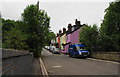
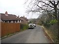
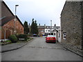
Colourful cottages on Apethorn Lane
Taken from the bridge over the active railway. There is also a bridge over a closed line beyond these cottages.
Image: © Bill Boaden
Taken: 9 Jun 2010
0.02 miles
10
Bridge #119
Bridge #119 takes Apethorn Lane over the former railway line from Godley Junction to Apethorn. The "Cheshire Lines Committee (CLC)" route opened in 1866. Following the electrification of the Woodhead line in 1954 and until 1981 when the through route to Sheffield closed, the main traffic on the line consisted of trains from the Yorkshire coalfield to the Fiddlers Ferry power station. Most of former trackbed is now utilised by the Trans Pennine Trail and National Cycle Network Route #62 but this section joined the main line from Hyde to Woodley a few hundred yards beyond this point and so is abandoned Image and access prevented by heavy railings across the front of the bridge.
Image: © Gerald England
Taken: 30 Sep 2016
0.03 miles