IMAGES TAKEN NEAR TO
Swiffin Close, HYDE, SK14 4XN
Introduction
This page details the photographs taken nearby to Swiffin Close, SK14 4XN by members of the Geograph project.
The Geograph project started in 2005 with the aim of publishing, organising and preserving representative images for every square kilometre of Great Britain, Ireland and the Isle of Man.

There are currently over 7.5m images from over14,400 individuals and you can help contribute to the project by visiting https://www.geograph.org.uk
Image Map
Images are licensed for reuse under creativecommons.org/licenses/by-sa/2.0
Notes
- Clicking on the map will re-center to the selected point.
- The higher the marker number, the further away the image location is from the centre of the postcode.
Image Listing (104 Images Found)
Images are licensed for reuse under creativecommons.org/licenses/by-sa/2.0
Image
Details
Distance
1
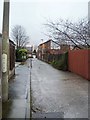
Johnson Brook Road
An old cobbled route leading towards Hyde North station.
Image: © Gerald England
Taken: 23 Jan 2010
0.03 miles
2
Johnsonbrook Road, Hyde/Dukinfield
On the Hyde/Dukinfield town boundary, viewed from the Hyde side.
Image: © John Topping
Taken: 17 Oct 2013
0.03 miles
3
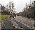
Johnson Brook Road
A green swathe of ground bordering Johnson Brook Road and Markham Street.
Image: © Gerald England
Taken: 19 May 2009
0.04 miles
4
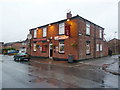
The Cotton Tree, Markham Street, Hyde
Image: © Alexander P Kapp
Taken: 6 Dec 2011
0.07 miles
5
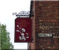
Signs: Whitnall Street, The Cotton Tree
The sign for the Cotton Tree Image
Image: © Gerald England
Taken: 18 Jun 2016
0.07 miles
6
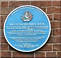
Blue plaque: The Cotton Tree
The blue plaque on the Cotton Tree Image reads:
TAMESIDE METROPOLITAN BOROUGH
THE COTTON TREE PUBLIC HOUSE
Opened in 1830 and so named as it coincided with the opening
of the cotton mills in the Newton area by the Ashton Brothers
Features prominently in the Chartist movement,
largely because Joseph Rayner Stephens, Dr. P.M. McDouall
and John Bradley were arrested as a result of a meeting
held here on 28th July 1839
A popular meeting place for the local Chartists where
crowds would meet after dark with firearms
and banners to further their cause
for political and social reform
Unveiled by
The Rt. Hon. Jack Cunningham, M.P.
on 18th December 1999
Image: © Gerald England
Taken: 18 Jun 2016
0.07 miles
7

The Cotton Tree
The Cotton Tree on the junction of Markham Street and Whitnall Street was opened in 1830 by Joseph Cash. Cash was dragged from his horse and beaten to death on 21st August 1833 but no-one was convicted of his murder.
The pub's association with the Chartists movement is documented on a blue plaque Image on the front of the building.
There are tales told of one man being hanged outside and of another being shot to death in the tap room.
Originally owned by the Ardwick brewers Issott's, by the 1970s it had become a Wilson's house. For a photograph and account from 1975 see http://hydonian.blogspot.co.uk/2016/06/hyde-pubs-1975-10.html
It closed in 2012 and although it has been converted into apartments it has retained some of the signage Image
Image: © Gerald England
Taken: 18 Jun 2016
0.07 miles
8
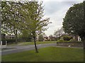
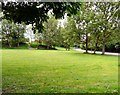
Markham Street
A windblown tree on grassland between Markham Street and Ashton Road, Newton.
Image: © Gerald England
Taken: 2 May 2012
0.08 miles
9
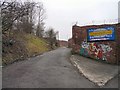
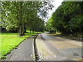
Off Johnson Brook Road
An industrial access road off Johnson Brook Road.
Image: © Gerald England
Taken: 23 Jan 2010
0.08 miles