IMAGES TAKEN NEAR TO
Whitehart Street, HYDE, SK14 4SL
Introduction
This page details the photographs taken nearby to Whitehart Street, SK14 4SL by members of the Geograph project.
The Geograph project started in 2005 with the aim of publishing, organising and preserving representative images for every square kilometre of Great Britain, Ireland and the Isle of Man.

There are currently over 7.5m images from over14,400 individuals and you can help contribute to the project by visiting https://www.geograph.org.uk
Image Map
Images are licensed for reuse under creativecommons.org/licenses/by-sa/2.0
Notes
- Clicking on the map will re-center to the selected point.
- The higher the marker number, the further away the image location is from the centre of the postcode.
Image Listing (100 Images Found)
Images are licensed for reuse under creativecommons.org/licenses/by-sa/2.0
Image
Details
Distance
1

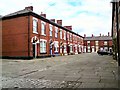
Thomas Ashton School
Thomas Ashton school on Bennett Street was designed by Rock Townsend http://www.rocktownsend.co.uk/thomas-ashton/ for Tameside MBC and contractors Clarilion Plc. The school for children aged 7-14 with special needs was previously located on Grange Road South Image having changed its name from Dale Grove School.
Image: © Gerald England
Taken: 13 Apr 2016
0.11 miles
3
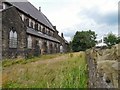
St Stephen's churchyard
Since closing a year ago the churchyard at the rear has gone wild. In the background is a glimpse of Thomas Ashton school.
Image: © Gerald England
Taken: 21 Jul 2012
0.12 miles
4
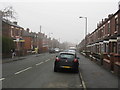
Gair Street
Terraced street off Old Road, Flowery Field.
Image: © Gerald England
Taken: 13 Jul 2011
0.12 miles
5
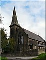
St Stephen's Church
The south-western aspect.
Image: © Gerald England
Taken: 3 Oct 2008
0.13 miles
6
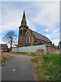
St Stephen's Church
The southwest aspect of the church.
Image: © Gerald England
Taken: 13 Apr 2016
0.13 miles
7

St Stephen's, Flowery Field
The south side of the now closed church.
Image: © Gerald England
Taken: 21 Jul 2012
0.13 miles
8

Flowery Field Railway Station
The Northern Rail train to Hadfield has just left Flowery Field Station.
Image: © David Dixon
Taken: 9 Nov 2012
0.13 miles
9
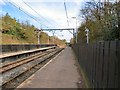
Flowery Field Station
The station on the line from Manchester to Hadfield and Glossop was opened in May 1985.
Image: © Gerald England
Taken: 13 Apr 2016
0.13 miles
10
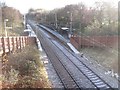
Flowery Field railway station
Opened in 1985 by British Rail on the line from Manchester Piccadilly to Glossop. View south west towards Newton for Hyde and Glossop, on a frosty day.
Image: © Nigel Thompson
Taken: 27 Nov 2010
0.13 miles