IMAGES TAKEN NEAR TO
Mary Street, HYDE, SK14 4RD
Introduction
This page details the photographs taken nearby to Mary Street, SK14 4RD by members of the Geograph project.
The Geograph project started in 2005 with the aim of publishing, organising and preserving representative images for every square kilometre of Great Britain, Ireland and the Isle of Man.

There are currently over 7.5m images from over14,400 individuals and you can help contribute to the project by visiting https://www.geograph.org.uk
Image Map
Images are licensed for reuse under creativecommons.org/licenses/by-sa/2.0
Notes
- Clicking on the map will re-center to the selected point.
- The higher the marker number, the further away the image location is from the centre of the postcode.
Image Listing (826 Images Found)
Images are licensed for reuse under creativecommons.org/licenses/by-sa/2.0
Image
Details
Distance
1
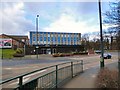
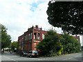
Orient House
Office space on Newton Street.
Image: © Gerald England
Taken: 23 Feb 2015
0.02 miles
2
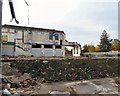
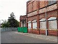
Caxton Works Cleared
The Caxton Works Image has been demolished, although the Mary Street facade Image still remains. More about the demolition at http://spadsky-hydedailyphoto.blogspot.com/2009/08/caxton-demolition-continued.html
Image: © Gerald England
Taken: 19 Oct 2009
0.02 miles
3
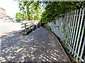
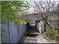
Mary Street underpass
The underpass leading from Mary Street under Clark Way.
Image: © Gerald England
Taken: 29 May 2016
0.02 miles
4
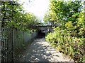
Mary Street underpass
The underpass leading to Mary Street under Clark Way.
Image: © Gerald England
Taken: 29 May 2016
0.02 miles
5
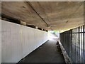
Mary Street Underpass
Underpass from Mary Street under Clark Way. The white wall has recently been cleaned. Usually it is covered in graffiti.
Image: © Gerald England
Taken: 10 Apr 2011
0.02 miles
6
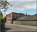
Edward Street
Coming into Hyde from Dukinfield Road. Just before the junction with Newton Street is Edward Street on which lies Caxton Works. Although advertised for sale, it appears to be in very sorry state of repair.
Image: © Gerald England
Taken: 11 Sep 2008
0.03 miles
7
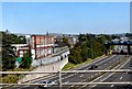
Mary Street
To the left is the M67 motorway. On the right is the Caxton Works in the process of being demolished. More information at http://spadsky-hydedailyphoto.blogspot.com/2009/08/caxton-demolition-continued.html
Image: © Gerald England
Taken: 8 Aug 2009
0.03 miles
8
Mary Street
The Caxton Mill on Mary Street. The Mary Street facade is still intact whilst the main part of the mill on Edward Street is being demolished. More information at http://spadsky-hydedailyphoto.blogspot.com/2009/07/caxton-works-demolition.html
Image: © Gerald England
Taken: 13 Jul 2009
0.03 miles
9
Under Clark Way
Underpass leading from Pitt St to Mary St under Clark Way. The M67 motorway lies below on the left.
Image: © Gerald England
Taken: 14 Apr 2008
0.03 miles
10
Mary Street and the M67
A view of Mary Street Image and the remains of the demolished Caxton Works from a train crossing the M67.
Image: © Gerald England
Taken: 12 Sep 2009
0.03 miles